You are here: Home > Network List > US - United States National Seismic Network Stations List
> Station AMTX Amarillo, Texas, USA > Earthquake Result Viewer
AMTX Amarillo, Texas, USA - Earthquake Result Viewer
*The percent match for this event was below the threshold and hence no stack was calculated.
| Earthquake location: |
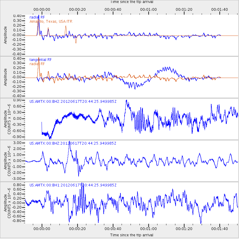
Near East Coast Of Honshu, Japan |
| Earthquake latitude/longitude: |
38.9/141.8 |
| Earthquake time(UTC): |
2012/06/17 (169) 20:32:20 GMT |
| Earthquake Depth: |
36 km |
| Earthquake Magnitude: |
6.0 MB, 5.9 MS, 6.3 MW, 6.4 MW |
| Earthquake Catalog/Contributor: |
WHDF/NEIC |
|
| Network: |
US United States National Seismic Network |
| Station: |
AMTX Amarillo, Texas, USA |
| Lat/Lon: |
34.53 N/101.41 W |
| Elevation: |
1010 m |
|
| Distance: |
86.4 deg |
| Az: |
47.616 deg |
| Baz: |
315.739 deg |
| Ray Param: |
$rayparam |
*The percent match for this event was below the threshold and hence was not used in the summary stack. |
|
| Radial Match: |
79.90989 % |
| Radial Bump: |
400 |
| Transverse Match: |
55.268246 % |
| Transverse Bump: |
400 |
| SOD ConfigId: |
558545 |
| Insert Time: |
2013-09-19 20:47:43.713 +0000 |
| GWidth: |
2.5 |
| Max Bumps: |
400 |
| Tol: |
0.001 |
|
Signal To Noise
| Channel | StoN | STA | LTA |
| US:AMTX:00:BHZ:20120617T20:44:25.949985Z | 11.132974 | 8.347869E-7 | 7.4983284E-8 |
| US:AMTX:00:BH1:20120617T20:44:25.949985Z | 1.9167715 | 3.1333857E-7 | 1.6347205E-7 |
| US:AMTX:00:BH2:20120617T20:44:25.949985Z | 0.801665 | 2.9142632E-7 | 3.635263E-7 |
| Arrivals |
| Ps | |
| PpPs | |
| PsPs/PpSs | |


