You are here: Home > Network List > US - United States National Seismic Network Stations List
> Station MSO Missoula, Montana, USA > Earthquake Result Viewer
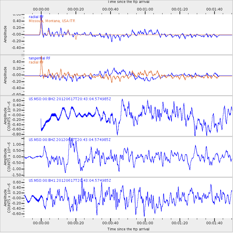
MSO Missoula, Montana, USA - Earthquake Result Viewer
*The percent match for this event was below the threshold and hence no stack was calculated.
| Earthquake location: |
Near East Coast Of Honshu, Japan |
| Earthquake latitude/longitude: |
38.9/141.8 |
| Earthquake time(UTC): |
2012/06/17 (169) 20:32:20 GMT |
| Earthquake Depth: |
36 km |
| Earthquake Magnitude: |
6.0 MB, 5.9 MS, 6.3 MW, 6.4 MW |
| Earthquake Catalog/Contributor: |
WHDF/NEIC |
|
| Network: |
US United States National Seismic Network |
| Station: |
MSO Missoula, Montana, USA |
| Lat/Lon: |
46.83 N/113.94 W |
| Elevation: |
1264 m |
|
| Distance: |
71.1 deg |
| Az: |
44.693 deg |
| Baz: |
306.96 deg |
| Ray Param: |
$rayparam |
*The percent match for this event was below the threshold and hence was not used in the summary stack. |
|
| Radial Match: |
72.015526 % |
| Radial Bump: |
400 |
| Transverse Match: |
43.412823 % |
| Transverse Bump: |
400 |
| SOD ConfigId: |
558545 |
| Insert Time: |
2013-09-19 20:49:15.695 +0000 |
| GWidth: |
2.5 |
| Max Bumps: |
400 |
| Tol: |
0.001 |
|
Signal To Noise
| Channel | StoN | STA | LTA |
| US:MSO:00:BHZ:20120617T20:43:04.574985Z | 5.5433006 | 4.3286965E-7 | 7.8088796E-8 |
| US:MSO:00:BH1:20120617T20:43:04.574985Z | 2.7914655 | 1.8477455E-7 | 6.619267E-8 |
| US:MSO:00:BH2:20120617T20:43:04.574985Z | 0.76930594 | 1.6789205E-7 | 2.1823836E-7 |
| Arrivals |
| Ps | |
| PpPs | |
| PsPs/PpSs | |


