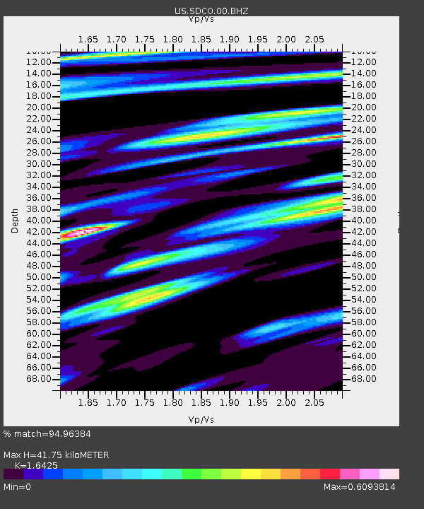
SDCO Great Sand Dunes National Park, Colorado, USA - Earthquake Result Viewer

Earthquake location: Near Islands, Aleutian Islands
Earthquake latitude/longitude: 53.4/171.6
Earthquake time(UTC): 2012/06/19 (171) 15:56:32 GMT
Earthquake Depth: 14 km
Earthquake Magnitude: 6.2 MB, 5.7 MS, 6.0 MW, 6.1 MW
Earthquake Catalog/Contributor: WHDF/NEIC
Network: US United States National Seismic Network
Station: SDCO Great Sand Dunes National Park, Colorado, USA
Lat/Lon: 37.75 N/105.50 W
Elevation: 2569 m
Distance: 56.9 deg
Az: 69.968 deg
Baz: 314.725 deg
Ray Param: 0.06386129
Estimated Moho Depth: 41.75 km
Estimated Crust Vp/Vs: 1.64
Assumed Crust Vp: 6.316 km/s
Estimated Crust Vs: 3.845 km/s
Estimated Crust Poisson's Ratio: 0.21
Radial Match: 94.96384 %
Radial Bump: 400
Transverse Match: 79.69787 %
Transverse Bump: 400
SOD ConfigId: 558545
Insert Time: 2013-09-19 20:54:45.533 +0000
GWidth: 2.5
Max Bumps: 400
Tol: 0.001

Signal To Noise

ChannelStoNSTALTA
US:SDCO:00:BHZ:20120619T16:05:45.499971Z19.6544741.5103517E-67.684518E-8
US:SDCO:00:BH1:20120619T16:05:45.499971Z8.5092473.7193894E-74.370997E-8
US:SDCO:00:BH2:20120619T16:05:45.499971Z16.2707587.476857E-74.5952728E-8
Arrivals
Ps4.5 SECOND
PpPs17 SECOND
PsPs/PpSs21 SECOND