You are here: Home > Network List > US - United States National Seismic Network Stations List
> Station COWI Conover, Wisconsin, USA > Earthquake Result Viewer
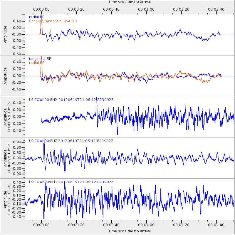
COWI Conover, Wisconsin, USA - Earthquake Result Viewer
*The percent match for this event was below the threshold and hence no stack was calculated.
| Earthquake location: |
Near Islands, Aleutian Islands |
| Earthquake latitude/longitude: |
53.4/171.7 |
| Earthquake time(UTC): |
2012/06/19 (171) 20:56:41 GMT |
| Earthquake Depth: |
12 km |
| Earthquake Magnitude: |
5.9 MB, 5.2 MS, 5.6 MW, 5.7 MW |
| Earthquake Catalog/Contributor: |
WHDF/NEIC |
|
| Network: |
US United States National Seismic Network |
| Station: |
COWI Conover, Wisconsin, USA |
| Lat/Lon: |
46.10 N/89.14 W |
| Elevation: |
523 m |
|
| Distance: |
59.4 deg |
| Az: |
52.915 deg |
| Baz: |
316.583 deg |
| Ray Param: |
$rayparam |
*The percent match for this event was below the threshold and hence was not used in the summary stack. |
|
| Radial Match: |
64.16695 % |
| Radial Bump: |
400 |
| Transverse Match: |
46.241558 % |
| Transverse Bump: |
400 |
| SOD ConfigId: |
558545 |
| Insert Time: |
2013-09-19 20:58:05.145 +0000 |
| GWidth: |
2.5 |
| Max Bumps: |
400 |
| Tol: |
0.001 |
|
Signal To Noise
| Channel | StoN | STA | LTA |
| US:COWI:00:BHZ:20120619T21:06:12.823992Z | 6.4367948 | 3.6120642E-7 | 5.611588E-8 |
| US:COWI:00:BH1:20120619T21:06:12.823992Z | 3.5320165 | 2.11388E-7 | 5.98491E-8 |
| US:COWI:00:BH2:20120619T21:06:12.823992Z | 3.0632014 | 1.8983081E-7 | 6.197138E-8 |
| Arrivals |
| Ps | |
| PpPs | |
| PsPs/PpSs | |


