You are here: Home > Network List > US - United States National Seismic Network Stations List
> Station HAWA Hanford, Washington, USA > Earthquake Result Viewer
HAWA Hanford, Washington, USA - Earthquake Result Viewer
*The percent match for this event was below the threshold and hence no stack was calculated.
| Earthquake location: |
Near Islands, Aleutian Islands |
| Earthquake latitude/longitude: |
53.4/171.7 |
| Earthquake time(UTC): |
2012/06/19 (171) 20:56:41 GMT |
| Earthquake Depth: |
12 km |
| Earthquake Magnitude: |
5.9 MB, 5.2 MS, 5.6 MW, 5.7 MW |
| Earthquake Catalog/Contributor: |
WHDF/NEIC |
|
| Network: |
US United States National Seismic Network |
| Station: |
HAWA Hanford, Washington, USA |
| Lat/Lon: |
46.39 N/119.53 W |
| Elevation: |
364 m |
|
| Distance: |
43.3 deg |
| Az: |
70.217 deg |
| Baz: |
305.41 deg |
| Ray Param: |
$rayparam |
*The percent match for this event was below the threshold and hence was not used in the summary stack. |
|
| Radial Match: |
69.31785 % |
| Radial Bump: |
400 |
| Transverse Match: |
46.240936 % |
| Transverse Bump: |
400 |
| SOD ConfigId: |
558545 |
| Insert Time: |
2013-09-19 20:58:22.527 +0000 |
| GWidth: |
2.5 |
| Max Bumps: |
400 |
| Tol: |
0.001 |
|
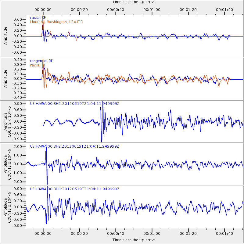
Signal To Noise
| Channel | StoN | STA | LTA |
| US:HAWA:00:BHZ:20120619T21:04:11.949999Z | 5.6000543 | 8.3326313E-7 | 1.4879555E-7 |
| US:HAWA:00:BH1:20120619T21:04:11.949999Z | 4.5438337 | 3.9428554E-7 | 8.677376E-8 |
| US:HAWA:00:BH2:20120619T21:04:11.949999Z | 4.6741533 | 4.4718848E-7 | 9.567261E-8 |
| Arrivals |
| Ps | |
| PpPs | |
| PsPs/PpSs | |


