You are here: Home > Network List > IU - Global Seismograph Network (GSN - IRIS/USGS) Stations List
> Station HNR Honiara, Solomon Islands > Earthquake Result Viewer
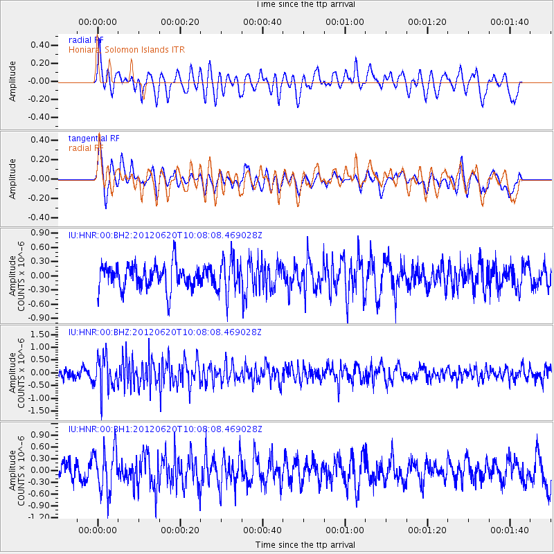
HNR Honiara, Solomon Islands - Earthquake Result Viewer
*The percent match for this event was below the threshold and hence no stack was calculated.
| Earthquake location: |
Southern Sumatra, Indonesia |
| Earthquake latitude/longitude: |
-4.9/103.2 |
| Earthquake time(UTC): |
2012/06/20 (172) 09:59:04 GMT |
| Earthquake Depth: |
70 km |
| Earthquake Magnitude: |
5.6 MB, 5.2 MW, 5.3 MW |
| Earthquake Catalog/Contributor: |
WHDF/NEIC |
|
| Network: |
IU Global Seismograph Network (GSN - IRIS/USGS) |
| Station: |
HNR Honiara, Solomon Islands |
| Lat/Lon: |
9.44 S/159.95 E |
| Elevation: |
100 m |
|
| Distance: |
56.4 deg |
| Az: |
98.014 deg |
| Baz: |
270.33 deg |
| Ray Param: |
$rayparam |
*The percent match for this event was below the threshold and hence was not used in the summary stack. |
|
| Radial Match: |
59.473793 % |
| Radial Bump: |
400 |
| Transverse Match: |
65.17045 % |
| Transverse Bump: |
400 |
| SOD ConfigId: |
558545 |
| Insert Time: |
2013-09-19 21:02:15.776 +0000 |
| GWidth: |
2.5 |
| Max Bumps: |
400 |
| Tol: |
0.001 |
|
Signal To Noise
| Channel | StoN | STA | LTA |
| IU:HNR:00:BHZ:20120620T10:08:08.469028Z | 2.860927 | 6.5391555E-7 | 2.2856771E-7 |
| IU:HNR:00:BH1:20120620T10:08:08.469028Z | 1.8461628 | 5.536169E-7 | 2.998744E-7 |
| IU:HNR:00:BH2:20120620T10:08:08.469028Z | 1.4576033 | 3.7486538E-7 | 2.5717927E-7 |
| Arrivals |
| Ps | |
| PpPs | |
| PsPs/PpSs | |


