You are here: Home > Network List > II - Global Seismograph Network (GSN - IRIS/IDA) Stations List
> Station KAPI Kappang, Sulawesi, Indonesia > Earthquake Result Viewer
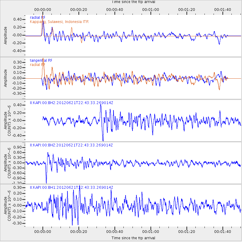
KAPI Kappang, Sulawesi, Indonesia - Earthquake Result Viewer
*The percent match for this event was below the threshold and hence no stack was calculated.
| Earthquake location: |
Fiji Islands Region |
| Earthquake latitude/longitude: |
-18.0/-178.2 |
| Earthquake time(UTC): |
2012/06/21 (173) 22:34:37 GMT |
| Earthquake Depth: |
543 km |
| Earthquake Magnitude: |
5.5 MW, 5.2 MB, 5.5 MW |
| Earthquake Catalog/Contributor: |
WHDF/NEIC |
|
| Network: |
II Global Seismograph Network (GSN - IRIS/IDA) |
| Station: |
KAPI Kappang, Sulawesi, Indonesia |
| Lat/Lon: |
5.01 S/119.75 E |
| Elevation: |
300 m |
|
| Distance: |
61.9 deg |
| Az: |
273.928 deg |
| Baz: |
107.594 deg |
| Ray Param: |
$rayparam |
*The percent match for this event was below the threshold and hence was not used in the summary stack. |
|
| Radial Match: |
63.157978 % |
| Radial Bump: |
400 |
| Transverse Match: |
55.79839 % |
| Transverse Bump: |
400 |
| SOD ConfigId: |
558545 |
| Insert Time: |
2013-09-19 21:03:46.816 +0000 |
| GWidth: |
2.5 |
| Max Bumps: |
400 |
| Tol: |
0.001 |
|
Signal To Noise
| Channel | StoN | STA | LTA |
| II:KAPI:00:BHZ:20120621T22:43:33.269014Z | 5.8069983 | 3.711798E-7 | 6.3919394E-8 |
| II:KAPI:00:BH1:20120621T22:43:33.269014Z | 1.7448682 | 7.3926E-8 | 4.236767E-8 |
| II:KAPI:00:BH2:20120621T22:43:33.269014Z | 3.457079 | 2.1019981E-7 | 6.080272E-8 |
| Arrivals |
| Ps | |
| PpPs | |
| PsPs/PpSs | |


