You are here: Home > Network List > II - Global Seismograph Network (GSN - IRIS/IDA) Stations List
> Station PFO Pinon Flat, California, USA > Earthquake Result Viewer
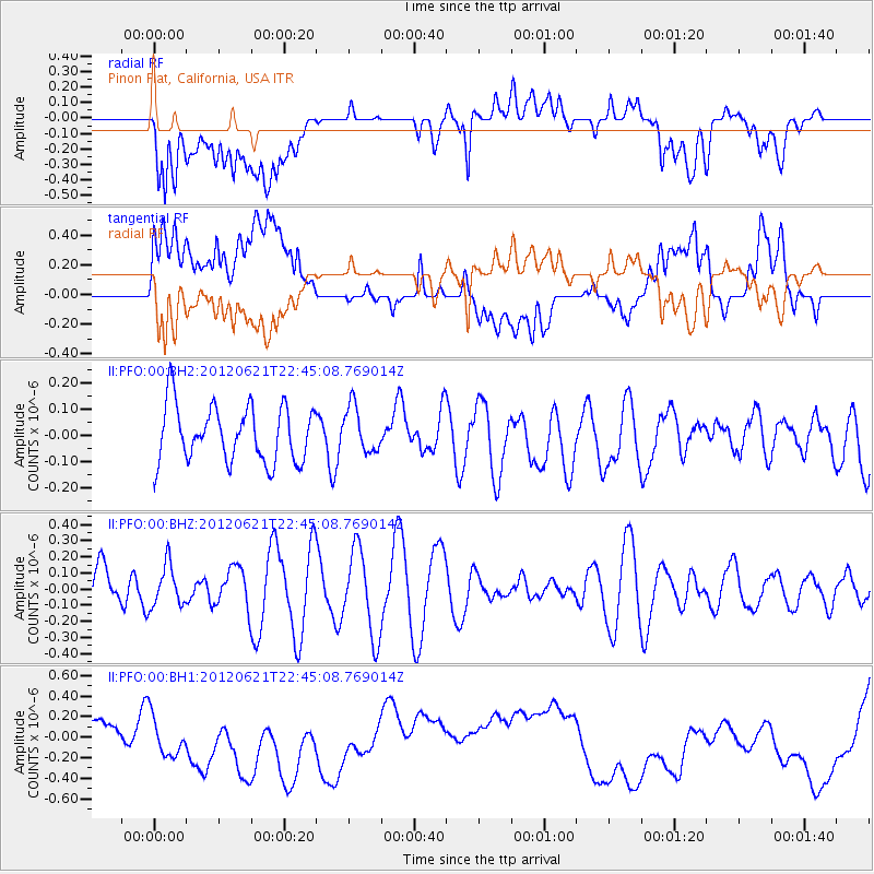
PFO Pinon Flat, California, USA - Earthquake Result Viewer
*The percent match for this event was below the threshold and hence no stack was calculated.
| Earthquake location: |
Fiji Islands Region |
| Earthquake latitude/longitude: |
-18.0/-178.2 |
| Earthquake time(UTC): |
2012/06/21 (173) 22:34:37 GMT |
| Earthquake Depth: |
543 km |
| Earthquake Magnitude: |
5.5 MW, 5.2 MB, 5.5 MW |
| Earthquake Catalog/Contributor: |
WHDF/NEIC |
|
| Network: |
II Global Seismograph Network (GSN - IRIS/IDA) |
| Station: |
PFO Pinon Flat, California, USA |
| Lat/Lon: |
33.61 N/116.46 W |
| Elevation: |
1280 m |
|
| Distance: |
78.0 deg |
| Az: |
48.705 deg |
| Baz: |
238.976 deg |
| Ray Param: |
$rayparam |
*The percent match for this event was below the threshold and hence was not used in the summary stack. |
|
| Radial Match: |
20.06526 % |
| Radial Bump: |
400 |
| Transverse Match: |
15.3543005 % |
| Transverse Bump: |
400 |
| SOD ConfigId: |
558545 |
| Insert Time: |
2013-09-19 21:03:51.372 +0000 |
| GWidth: |
2.5 |
| Max Bumps: |
400 |
| Tol: |
0.001 |
|
Signal To Noise
| Channel | StoN | STA | LTA |
| II:PFO:00:BHZ:20120621T22:45:08.769014Z | 0.48760784 | 1.2962096E-7 | 2.6583032E-7 |
| II:PFO:00:BH1:20120621T22:45:08.769014Z | 1.5421034 | 4.891364E-7 | 3.171878E-7 |
| II:PFO:00:BH2:20120621T22:45:08.769014Z | 0.8212215 | 8.7342215E-8 | 1.0635647E-7 |
| Arrivals |
| Ps | |
| PpPs | |
| PsPs/PpSs | |


