You are here: Home > Network List > IU - Global Seismograph Network (GSN - IRIS/USGS) Stations List
> Station JOHN Johnston Island, USA > Earthquake Result Viewer
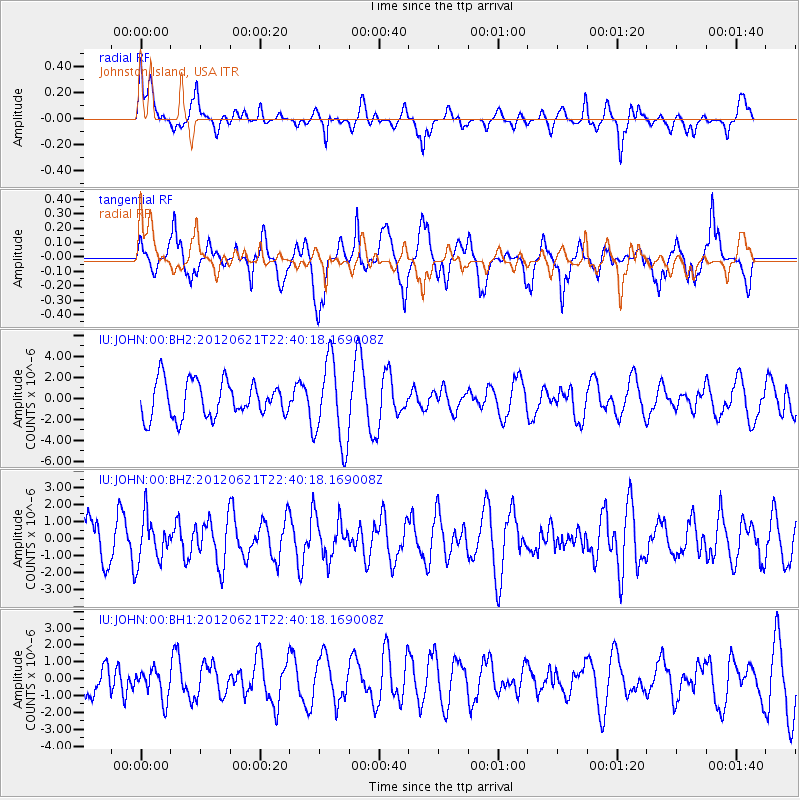
JOHN Johnston Island, USA - Earthquake Result Viewer
*The percent match for this event was below the threshold and hence no stack was calculated.
| Earthquake location: |
Fiji Islands Region |
| Earthquake latitude/longitude: |
-18.0/-178.2 |
| Earthquake time(UTC): |
2012/06/21 (173) 22:34:37 GMT |
| Earthquake Depth: |
543 km |
| Earthquake Magnitude: |
5.5 MW, 5.2 MB, 5.5 MW |
| Earthquake Catalog/Contributor: |
WHDF/NEIC |
|
| Network: |
IU Global Seismograph Network (GSN - IRIS/USGS) |
| Station: |
JOHN Johnston Island, USA |
| Lat/Lon: |
16.73 N/169.53 W |
| Elevation: |
2.0 m |
|
| Distance: |
35.5 deg |
| Az: |
14.375 deg |
| Baz: |
194.278 deg |
| Ray Param: |
$rayparam |
*The percent match for this event was below the threshold and hence was not used in the summary stack. |
|
| Radial Match: |
55.41332 % |
| Radial Bump: |
400 |
| Transverse Match: |
59.803085 % |
| Transverse Bump: |
400 |
| SOD ConfigId: |
558545 |
| Insert Time: |
2013-09-19 21:04:09.054 +0000 |
| GWidth: |
2.5 |
| Max Bumps: |
400 |
| Tol: |
0.001 |
|
Signal To Noise
| Channel | StoN | STA | LTA |
| IU:JOHN:00:BHZ:20120621T22:40:18.169008Z | 0.96474 | 1.2823834E-6 | 1.3292529E-6 |
| IU:JOHN:00:BH1:20120621T22:40:18.169008Z | 0.84907824 | 8.833844E-7 | 1.0404041E-6 |
| IU:JOHN:00:BH2:20120621T22:40:18.169008Z | 2.3535485 | 3.995696E-6 | 1.6977326E-6 |
| Arrivals |
| Ps | |
| PpPs | |
| PsPs/PpSs | |


