You are here: Home > Network List > IU - Global Seismograph Network (GSN - IRIS/USGS) Stations List
> Station PMG Port Moresby, New Guinea > Earthquake Result Viewer
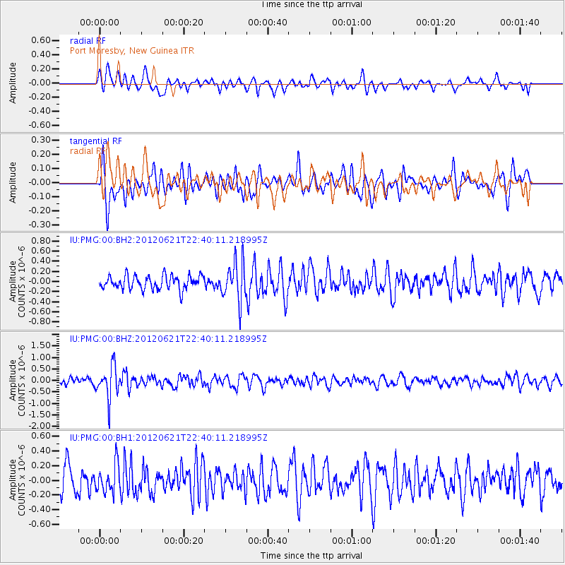
PMG Port Moresby, New Guinea - Earthquake Result Viewer
*The percent match for this event was below the threshold and hence no stack was calculated.
| Earthquake location: |
Fiji Islands Region |
| Earthquake latitude/longitude: |
-18.0/-178.2 |
| Earthquake time(UTC): |
2012/06/21 (173) 22:34:37 GMT |
| Earthquake Depth: |
543 km |
| Earthquake Magnitude: |
5.5 MW, 5.2 MB, 5.5 MW |
| Earthquake Catalog/Contributor: |
WHDF/NEIC |
|
| Network: |
IU Global Seismograph Network (GSN - IRIS/USGS) |
| Station: |
PMG Port Moresby, New Guinea |
| Lat/Lon: |
9.40 S/147.16 E |
| Elevation: |
90 m |
|
| Distance: |
34.7 deg |
| Az: |
279.539 deg |
| Baz: |
107.951 deg |
| Ray Param: |
$rayparam |
*The percent match for this event was below the threshold and hence was not used in the summary stack. |
|
| Radial Match: |
58.607594 % |
| Radial Bump: |
400 |
| Transverse Match: |
58.67782 % |
| Transverse Bump: |
400 |
| SOD ConfigId: |
558545 |
| Insert Time: |
2013-09-19 21:04:16.441 +0000 |
| GWidth: |
2.5 |
| Max Bumps: |
400 |
| Tol: |
0.001 |
|
Signal To Noise
| Channel | StoN | STA | LTA |
| IU:PMG:00:BHZ:20120621T22:40:11.218995Z | 4.306782 | 7.1648657E-7 | 1.6636241E-7 |
| IU:PMG:00:BH1:20120621T22:40:11.218995Z | 1.0753765 | 1.9426403E-7 | 1.8064746E-7 |
| IU:PMG:00:BH2:20120621T22:40:11.218995Z | 2.9527998 | 3.9482103E-7 | 1.3371074E-7 |
| Arrivals |
| Ps | |
| PpPs | |
| PsPs/PpSs | |


