You are here: Home > Network List > II - Global Seismograph Network (GSN - IRIS/IDA) Stations List
> Station WRAB Tennant Creek, NT, Australia > Earthquake Result Viewer
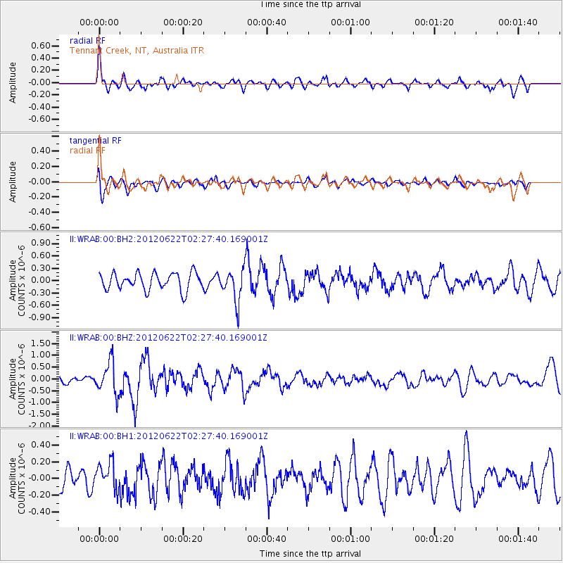
WRAB Tennant Creek, NT, Australia - Earthquake Result Viewer
*The percent match for this event was below the threshold and hence no stack was calculated.
| Earthquake location: |
South Of Kermadec Islands |
| Earthquake latitude/longitude: |
-32.9/-178.6 |
| Earthquake time(UTC): |
2012/06/22 (174) 02:20:06 GMT |
| Earthquake Depth: |
14 km |
| Earthquake Magnitude: |
5.5 MW, 5.4 MS, 5.3 MB, 5.7 MW |
| Earthquake Catalog/Contributor: |
WHDF/NEIC |
|
| Network: |
II Global Seismograph Network (GSN - IRIS/IDA) |
| Station: |
WRAB Tennant Creek, NT, Australia |
| Lat/Lon: |
19.93 S/134.36 E |
| Elevation: |
366 m |
|
| Distance: |
43.7 deg |
| Az: |
275.171 deg |
| Baz: |
117.1 deg |
| Ray Param: |
$rayparam |
*The percent match for this event was below the threshold and hence was not used in the summary stack. |
|
| Radial Match: |
74.10924 % |
| Radial Bump: |
400 |
| Transverse Match: |
65.9509 % |
| Transverse Bump: |
400 |
| SOD ConfigId: |
558545 |
| Insert Time: |
2013-09-19 21:06:12.080 +0000 |
| GWidth: |
2.5 |
| Max Bumps: |
400 |
| Tol: |
0.001 |
|
Signal To Noise
| Channel | StoN | STA | LTA |
| II:WRAB:00:BHZ:20120622T02:27:40.169001Z | 3.1278088 | 6.908317E-7 | 2.2086762E-7 |
| II:WRAB:00:BH1:20120622T02:27:40.169001Z | 0.9353462 | 1.6518652E-7 | 1.7660469E-7 |
| II:WRAB:00:BH2:20120622T02:27:40.169001Z | 1.978021 | 4.068195E-7 | 2.0566996E-7 |
| Arrivals |
| Ps | |
| PpPs | |
| PsPs/PpSs | |


