You are here: Home > Network List > IU - Global Seismograph Network (GSN - IRIS/USGS) Stations List
> Station HNR Honiara, Solomon Islands > Earthquake Result Viewer
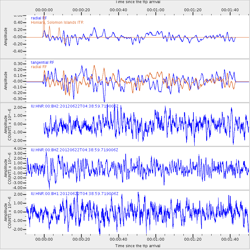
HNR Honiara, Solomon Islands - Earthquake Result Viewer
*The percent match for this event was below the threshold and hence no stack was calculated.
| Earthquake location: |
Macquarie Island Region |
| Earthquake latitude/longitude: |
-54.4/158.8 |
| Earthquake time(UTC): |
2012/06/22 (174) 04:31:17 GMT |
| Earthquake Depth: |
14 km |
| Earthquake Magnitude: |
5.9 MB, 5.5 MS, 5.7 MW, 5.8 MW |
| Earthquake Catalog/Contributor: |
WHDF/NEIC |
|
| Network: |
IU Global Seismograph Network (GSN - IRIS/USGS) |
| Station: |
HNR Honiara, Solomon Islands |
| Lat/Lon: |
9.44 S/159.95 E |
| Elevation: |
100 m |
|
| Distance: |
44.8 deg |
| Az: |
1.621 deg |
| Baz: |
180.961 deg |
| Ray Param: |
$rayparam |
*The percent match for this event was below the threshold and hence was not used in the summary stack. |
|
| Radial Match: |
63.862404 % |
| Radial Bump: |
400 |
| Transverse Match: |
57.38505 % |
| Transverse Bump: |
400 |
| SOD ConfigId: |
558545 |
| Insert Time: |
2013-09-19 21:08:11.807 +0000 |
| GWidth: |
2.5 |
| Max Bumps: |
400 |
| Tol: |
0.001 |
|
Signal To Noise
| Channel | StoN | STA | LTA |
| IU:HNR:00:BHZ:20120622T04:38:59.719006Z | 2.0852208 | 1.8650815E-6 | 8.944287E-7 |
| IU:HNR:00:BH1:20120622T04:38:59.719006Z | 1.5954348 | 9.785592E-7 | 6.133496E-7 |
| IU:HNR:00:BH2:20120622T04:38:59.719006Z | 1.6201651 | 8.7588285E-7 | 5.406133E-7 |
| Arrivals |
| Ps | |
| PpPs | |
| PsPs/PpSs | |


