You are here: Home > Network List > II - Global Seismograph Network (GSN - IRIS/IDA) Stations List
> Station ABPO Ambohimpanompo, Madagascar > Earthquake Result Viewer
ABPO Ambohimpanompo, Madagascar - Earthquake Result Viewer

| Earthquake location: |
Northern Sumatra, Indonesia |
| Earthquake latitude/longitude: |
3.0/97.9 |
| Earthquake time(UTC): |
2012/06/23 (175) 04:34:53 GMT |
| Earthquake Depth: |
95 km |
| Earthquake Magnitude: |
6.3 MB, 6.1 MW, 6.1 MW |
| Earthquake Catalog/Contributor: |
WHDF/NEIC |
|
| Network: |
II Global Seismograph Network (GSN - IRIS/IDA) |
| Station: |
ABPO Ambohimpanompo, Madagascar |
| Lat/Lon: |
19.02 S/47.23 E |
| Elevation: |
1528 m |
|
| Distance: |
54.4 deg |
| Az: |
244.137 deg |
| Baz: |
71.773 deg |
| Ray Param: |
0.065182105 |
| Estimated Moho Depth: |
22.75 km |
| Estimated Crust Vp/Vs: |
1.61 |
| Assumed Crust Vp: |
6.642 km/s |
| Estimated Crust Vs: |
4.132 km/s |
| Estimated Crust Poisson's Ratio: |
0.18 |
|
| Radial Match: |
80.75867 % |
| Radial Bump: |
336 |
| Transverse Match: |
71.15437 % |
| Transverse Bump: |
400 |
| SOD ConfigId: |
558545 |
| Insert Time: |
2013-09-19 21:09:17.390 +0000 |
| GWidth: |
2.5 |
| Max Bumps: |
400 |
| Tol: |
0.001 |
|
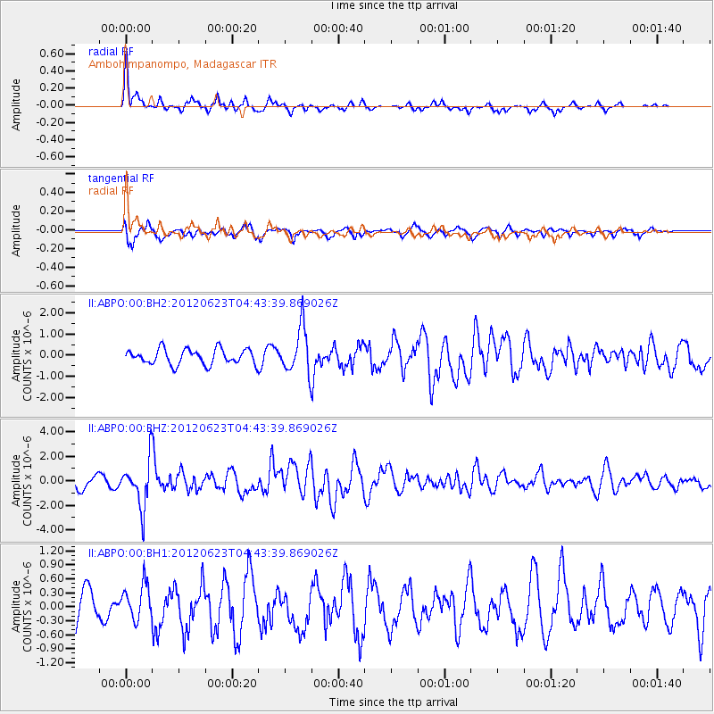
Signal To Noise
| Channel | StoN | STA | LTA |
| II:ABPO:00:BHZ:20120623T04:43:39.869026Z | 3.6030407 | 1.929825E-6 | 5.356101E-7 |
| II:ABPO:00:BH1:20120623T04:43:39.869026Z | 0.73135054 | 3.7760316E-7 | 5.163094E-7 |
| II:ABPO:00:BH2:20120623T04:43:39.869026Z | 3.0641837 | 1.1036408E-6 | 3.6017448E-7 |
| Arrivals |
| Ps | 2.2 SECOND |
| PpPs | 8.4 SECOND |
| PsPs/PpSs | 11 SECOND |


