You are here: Home > Network List > IU - Global Seismograph Network (GSN - IRIS/USGS) Stations List
> Station GNI Garni, Armenia > Earthquake Result Viewer
GNI Garni, Armenia - Earthquake Result Viewer
| Earthquake location: |
Northern Sumatra, Indonesia |
| Earthquake latitude/longitude: |
3.0/97.9 |
| Earthquake time(UTC): |
2012/06/23 (175) 04:34:53 GMT |
| Earthquake Depth: |
95 km |
| Earthquake Magnitude: |
6.3 MB, 6.1 MW, 6.1 MW |
| Earthquake Catalog/Contributor: |
WHDF/NEIC |
|
| Network: |
IU Global Seismograph Network (GSN - IRIS/USGS) |
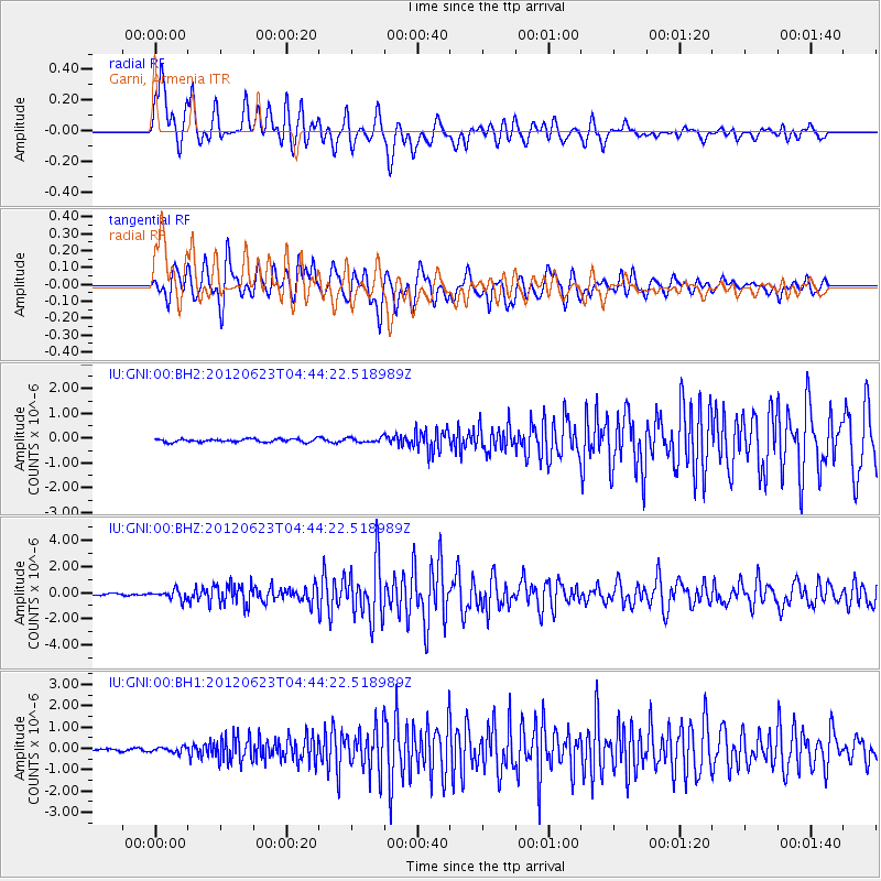
| Station: |
GNI Garni, Armenia |
| Lat/Lon: |
40.15 N/44.74 E |
| Elevation: |
1609 m |
|
| Distance: |
60.5 deg |
| Az: |
315.185 deg |
| Baz: |
113.327 deg |
| Ray Param: |
0.061226334 |
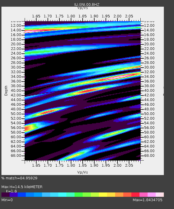
| Estimated Moho Depth: |
14.5 km |
| Estimated Crust Vp/Vs: |
1.60 |
| Assumed Crust Vp: |
6.291 km/s |
| Estimated Crust Vs: |
3.932 km/s |
| Estimated Crust Poisson's Ratio: |
0.18 |
|
| Radial Match: |
84.95929 % |
| Radial Bump: |
400 |
| Transverse Match: |
76.09482 % |
| Transverse Bump: |
400 |
| SOD ConfigId: |
558545 |
| Insert Time: |
2013-09-19 21:09:51.332 +0000 |
| GWidth: |
2.5 |
| Max Bumps: |
400 |
| Tol: |
0.001 |
|
Signal To Noise
| Channel | StoN | STA | LTA |
| IU:GNI:00:BHZ:20120623T04:44:22.518989Z | 5.3224974 | 3.553054E-7 | 6.675539E-8 |
| IU:GNI:00:BH1:20120623T04:44:22.518989Z | 2.419444 | 1.2432554E-7 | 5.1385992E-8 |
| IU:GNI:00:BH2:20120623T04:44:22.518989Z | 1.5579952 | 9.734113E-8 | 6.247845E-8 |
| Arrivals |
| Ps | 1.5 SECOND |
| PpPs | 5.7 SECOND |
| PsPs/PpSs | 7.2 SECOND |


