You are here: Home > Network List > IU - Global Seismograph Network (GSN - IRIS/USGS) Stations List
> Station HNR Honiara, Solomon Islands > Earthquake Result Viewer
HNR Honiara, Solomon Islands - Earthquake Result Viewer
| Earthquake location: |
Northern Sumatra, Indonesia |
| Earthquake latitude/longitude: |
3.0/97.9 |
| Earthquake time(UTC): |
2012/06/23 (175) 04:34:53 GMT |
| Earthquake Depth: |
95 km |
| Earthquake Magnitude: |
6.3 MB, 6.1 MW, 6.1 MW |
| Earthquake Catalog/Contributor: |
WHDF/NEIC |
|
| Network: |
IU Global Seismograph Network (GSN - IRIS/USGS) |
| Station: |
HNR Honiara, Solomon Islands |
| Lat/Lon: |
9.44 S/159.95 E |
| Elevation: |
100 m |
|
| Distance: |
63.0 deg |
| Az: |
102.098 deg |
| Baz: |
278.237 deg |
| Ray Param: |
0.059577595 |
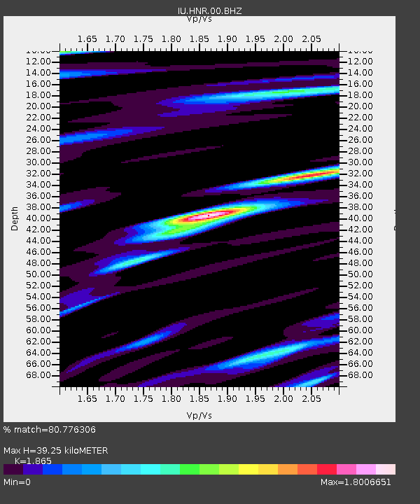
| Estimated Moho Depth: |
39.25 km |
| Estimated Crust Vp/Vs: |
1.87 |
| Assumed Crust Vp: |
6.183 km/s |
| Estimated Crust Vs: |
3.315 km/s |
| Estimated Crust Poisson's Ratio: |
0.30 |
|
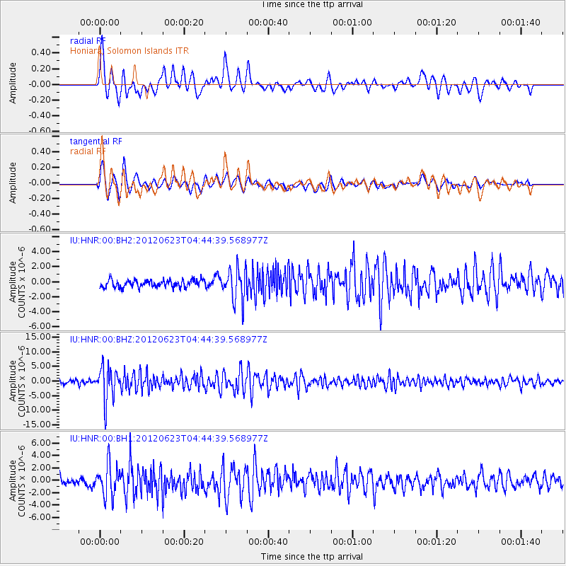
| Radial Match: |
80.776306 % |
| Radial Bump: |
400 |
| Transverse Match: |
81.45236 % |
| Transverse Bump: |
400 |
| SOD ConfigId: |
558545 |
| Insert Time: |
2013-09-19 21:09:55.127 +0000 |
| GWidth: |
2.5 |
| Max Bumps: |
400 |
| Tol: |
0.001 |
|
Signal To Noise
| Channel | StoN | STA | LTA |
| IU:HNR:00:BHZ:20120623T04:44:39.568977Z | 9.157815 | 5.765173E-6 | 6.2953586E-7 |
| IU:HNR:00:BH1:20120623T04:44:39.568977Z | 4.1498833 | 2.5879644E-6 | 6.236234E-7 |
| IU:HNR:00:BH2:20120623T04:44:39.568977Z | 4.477109 | 2.1878125E-6 | 4.8866633E-7 |
| Arrivals |
| Ps | 5.7 SECOND |
| PpPs | 18 SECOND |
| PsPs/PpSs | 23 SECOND |


