You are here: Home > Network List > US - United States National Seismic Network Stations List
> Station AAM Ann Arbor, Michigan, USA > Earthquake Result Viewer
AAM Ann Arbor, Michigan, USA - Earthquake Result Viewer
| Earthquake location: |
Near East Coast Of Kamchatka |
| Earthquake latitude/longitude: |
57.6/163.2 |
| Earthquake time(UTC): |
2012/06/24 (176) 03:15:01 GMT |
| Earthquake Depth: |
10 km |
| Earthquake Magnitude: |
5.8 MB, 5.8 MS, 6.0 MW, 6.1 MW |
| Earthquake Catalog/Contributor: |
WHDF/NEIC |
|
| Network: |
US United States National Seismic Network |
| Station: |
AAM Ann Arbor, Michigan, USA |
| Lat/Lon: |
42.30 N/83.66 W |
| Elevation: |
172 m |
|
| Distance: |
65.9 deg |
| Az: |
48.346 deg |
| Baz: |
327.164 deg |
| Ray Param: |
0.057957537 |
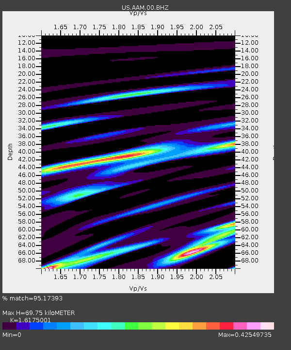
| Estimated Moho Depth: |
69.75 km |
| Estimated Crust Vp/Vs: |
1.62 |
| Assumed Crust Vp: |
6.483 km/s |
| Estimated Crust Vs: |
4.008 km/s |
| Estimated Crust Poisson's Ratio: |
0.19 |
|
| Radial Match: |
95.17393 % |
| Radial Bump: |
203 |
| Transverse Match: |
87.0376 % |
| Transverse Bump: |
335 |
| SOD ConfigId: |
558545 |
| Insert Time: |
2013-09-19 21:15:24.801 +0000 |
| GWidth: |
2.5 |
| Max Bumps: |
400 |
| Tol: |
0.001 |
|

Signal To Noise
| Channel | StoN | STA | LTA |
| US:AAM:00:BHZ:20120624T03:25:16.09897Z | 12.91661 | 8.5408766E-7 | 6.612321E-8 |
| US:AAM:00:BH1:20120624T03:25:16.09897Z | 4.970492 | 4.1873216E-7 | 8.42436E-8 |
| US:AAM:00:BH2:20120624T03:25:16.09897Z | 1.8269062 | 1.8831675E-7 | 1.0307959E-7 |
| Arrivals |
| Ps | 7.0 SECOND |
| PpPs | 27 SECOND |
| PsPs/PpSs | 34 SECOND |


