You are here: Home > Network List > CN - Canadian National Seismograph Network Stations List
> Station RES RESOLUTE, N.W.T. > Earthquake Result Viewer
RES RESOLUTE, N.W.T. - Earthquake Result Viewer
| Earthquake location: |
South Of Mariana Islands |
| Earthquake latitude/longitude: |
12.7/145.0 |
| Earthquake time(UTC): |
2001/10/12 (285) 15:02:16 GMT |
| Earthquake Depth: |
37 km |
| Earthquake Magnitude: |
6.7 MB, 7.3 MS, 7.0 MW, 6.9 MW |
| Earthquake Catalog/Contributor: |
WHDF/NEIC |
|
| Network: |
CN Canadian National Seismograph Network |
| Station: |
RES RESOLUTE, N.W.T. |
| Lat/Lon: |
74.69 N/94.90 W |
| Elevation: |
15 m |
|
| Distance: |
85.4 deg |
| Az: |
13.333 deg |
| Baz: |
302.128 deg |
| Ray Param: |
0.0447403 |
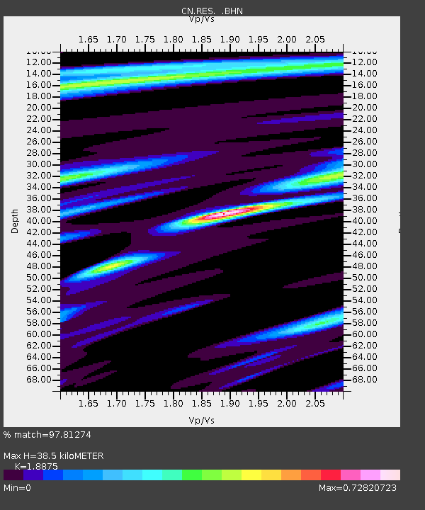
| Estimated Moho Depth: |
38.5 km |
| Estimated Crust Vp/Vs: |
1.89 |
| Assumed Crust Vp: |
6.367 km/s |
| Estimated Crust Vs: |
3.373 km/s |
| Estimated Crust Poisson's Ratio: |
0.30 |
|
| Radial Match: |
97.81274 % |
| Radial Bump: |
307 |
| Transverse Match: |
92.69336 % |
| Transverse Bump: |
400 |
| SOD ConfigId: |
20082 |
| Insert Time: |
2010-02-27 07:06:32.813 +0000 |
| GWidth: |
2.5 |
| Max Bumps: |
400 |
| Tol: |
0.001 |
|
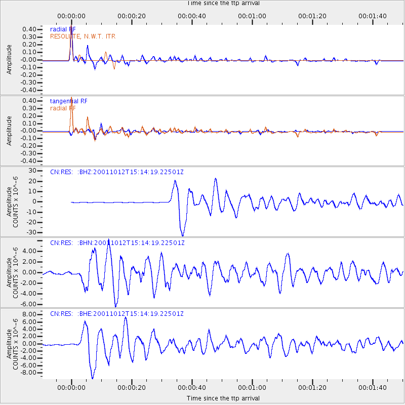
Signal To Noise
| Channel | StoN | STA | LTA |
| CN:RES: :BHN:20011012T15:14:19.22501Z | 7.3200183 | 1.289613E-6 | 1.761762E-7 |
| CN:RES: :BHE:20011012T15:14:19.22501Z | 18.012114 | 2.5909274E-6 | 1.438436E-7 |
| CN:RES: :BHZ:20011012T15:14:19.22501Z | 54.345146 | 8.701836E-6 | 1.6012169E-7 |
| Arrivals |
| Ps | 5.5 SECOND |
| PpPs | 17 SECOND |
| PsPs/PpSs | 23 SECOND |


