You are here: Home > Network List > US - United States National Seismic Network Stations List
> Station DGMT Dagmar, Montana, USA > Earthquake Result Viewer
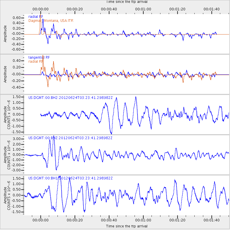
DGMT Dagmar, Montana, USA - Earthquake Result Viewer
*The percent match for this event was below the threshold and hence no stack was calculated.
| Earthquake location: |
Near East Coast Of Kamchatka |
| Earthquake latitude/longitude: |
57.6/163.2 |
| Earthquake time(UTC): |
2012/06/24 (176) 03:15:01 GMT |
| Earthquake Depth: |
10 km |
| Earthquake Magnitude: |
5.8 MB, 5.8 MS, 6.0 MW, 6.1 MW |
| Earthquake Catalog/Contributor: |
WHDF/NEIC |
|
| Network: |
US United States National Seismic Network |
| Station: |
DGMT Dagmar, Montana, USA |
| Lat/Lon: |
48.47 N/104.20 W |
| Elevation: |
0.0 m |
|
| Distance: |
52.2 deg |
| Az: |
57.265 deg |
| Baz: |
317.118 deg |
| Ray Param: |
$rayparam |
*The percent match for this event was below the threshold and hence was not used in the summary stack. |
|
| Radial Match: |
95.839905 % |
| Radial Bump: |
277 |
| Transverse Match: |
73.41305 % |
| Transverse Bump: |
400 |
| SOD ConfigId: |
558545 |
| Insert Time: |
2013-09-19 21:15:55.414 +0000 |
| GWidth: |
2.5 |
| Max Bumps: |
400 |
| Tol: |
0.001 |
|
Signal To Noise
| Channel | StoN | STA | LTA |
| US:DGMT:00:BHZ:20120624T03:23:41.298982Z | 14.792951 | 9.707383E-7 | 6.562168E-8 |
| US:DGMT:00:BH1:20120624T03:23:41.298982Z | 2.4248798 | 3.7378152E-7 | 1.5414436E-7 |
| US:DGMT:00:BH2:20120624T03:23:41.298982Z | 2.0776944 | 3.0253187E-7 | 1.456094E-7 |
| Arrivals |
| Ps | |
| PpPs | |
| PsPs/PpSs | |


