You are here: Home > Network List > US - United States National Seismic Network Stations List
> Station HDIL Hopedale, Illinois, USA > Earthquake Result Viewer
HDIL Hopedale, Illinois, USA - Earthquake Result Viewer
| Earthquake location: |
Near East Coast Of Kamchatka |
| Earthquake latitude/longitude: |
57.6/163.2 |
| Earthquake time(UTC): |
2012/06/24 (176) 03:15:01 GMT |
| Earthquake Depth: |
10 km |
| Earthquake Magnitude: |
5.8 MB, 5.8 MS, 6.0 MW, 6.1 MW |
| Earthquake Catalog/Contributor: |
WHDF/NEIC |
|
| Network: |
US United States National Seismic Network |
| Station: |
HDIL Hopedale, Illinois, USA |
| Lat/Lon: |
40.56 N/89.29 W |
| Elevation: |
219 m |
|
| Distance: |
65.0 deg |
| Az: |
53.286 deg |
| Baz: |
325.498 deg |
| Ray Param: |
0.058549058 |
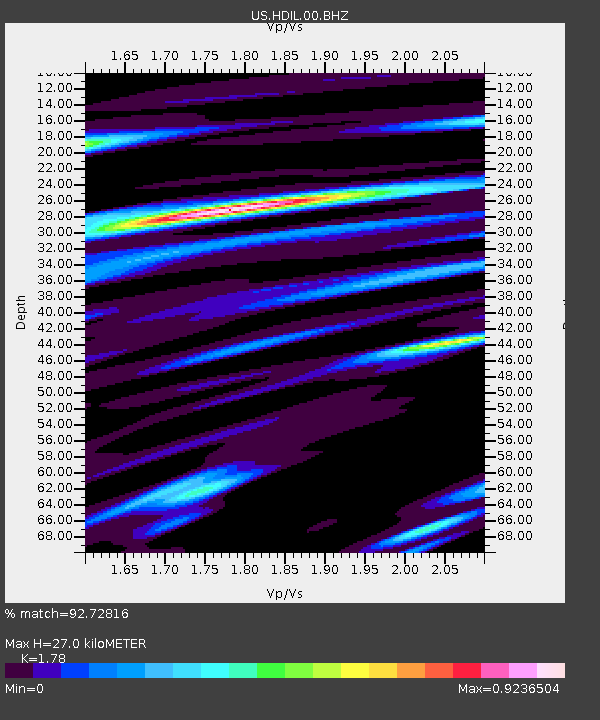
| Estimated Moho Depth: |
27.0 km |
| Estimated Crust Vp/Vs: |
1.78 |
| Assumed Crust Vp: |
6.498 km/s |
| Estimated Crust Vs: |
3.65 km/s |
| Estimated Crust Poisson's Ratio: |
0.27 |
|
| Radial Match: |
92.72816 % |
| Radial Bump: |
400 |
| Transverse Match: |
67.85968 % |
| Transverse Bump: |
400 |
| SOD ConfigId: |
558545 |
| Insert Time: |
2013-09-19 21:16:15.504 +0000 |
| GWidth: |
2.5 |
| Max Bumps: |
400 |
| Tol: |
0.001 |
|

Signal To Noise
| Channel | StoN | STA | LTA |
| US:HDIL:00:BHZ:20120624T03:25:10.298982Z | 11.605578 | 8.361351E-7 | 7.2045964E-8 |
| US:HDIL:00:BH1:20120624T03:25:10.298982Z | 4.2562814 | 4.365247E-7 | 1.02560115E-7 |
| US:HDIL:00:BH2:20120624T03:25:10.298982Z | 2.031711 | 2.1489632E-7 | 1.057711E-7 |
| Arrivals |
| Ps | 3.4 SECOND |
| PpPs | 11 SECOND |
| PsPs/PpSs | 14 SECOND |


