You are here: Home > Network List > II - Global Seismograph Network (GSN - IRIS/IDA) Stations List
> Station PFO Pinon Flat, California, USA > Earthquake Result Viewer
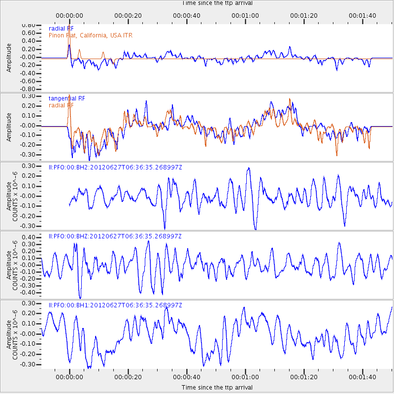
PFO Pinon Flat, California, USA - Earthquake Result Viewer
*The percent match for this event was below the threshold and hence no stack was calculated.
| Earthquake location: |
El Salvador |
| Earthquake latitude/longitude: |
13.8/-90.0 |
| Earthquake time(UTC): |
2012/06/27 (179) 06:30:59 GMT |
| Earthquake Depth: |
133 km |
| Earthquake Magnitude: |
5.7 MW, 5.4 MB, 5.7 MW |
| Earthquake Catalog/Contributor: |
WHDF/NEIC |
|
| Network: |
II Global Seismograph Network (GSN - IRIS/IDA) |
| Station: |
PFO Pinon Flat, California, USA |
| Lat/Lon: |
33.61 N/116.46 W |
| Elevation: |
1280 m |
|
| Distance: |
31.1 deg |
| Az: |
313.863 deg |
| Baz: |
122.942 deg |
| Ray Param: |
$rayparam |
*The percent match for this event was below the threshold and hence was not used in the summary stack. |
|
| Radial Match: |
56.623604 % |
| Radial Bump: |
400 |
| Transverse Match: |
43.14202 % |
| Transverse Bump: |
400 |
| SOD ConfigId: |
558545 |
| Insert Time: |
2013-09-19 21:20:08.355 +0000 |
| GWidth: |
2.5 |
| Max Bumps: |
400 |
| Tol: |
0.001 |
|
Signal To Noise
| Channel | StoN | STA | LTA |
| II:PFO:00:BHZ:20120627T06:36:35.268997Z | 1.5856605 | 2.3087289E-7 | 1.4560045E-7 |
| II:PFO:00:BH1:20120627T06:36:35.268997Z | 1.4843694 | 1.8129226E-7 | 1.221342E-7 |
| II:PFO:00:BH2:20120627T06:36:35.268997Z | 2.3177812 | 1.3580357E-7 | 5.8592057E-8 |
| Arrivals |
| Ps | |
| PpPs | |
| PsPs/PpSs | |


