You are here: Home > Network List > US - United States National Seismic Network Stations List
> Station EGMT Eagleton, Montana, USA > Earthquake Result Viewer
EGMT Eagleton, Montana, USA - Earthquake Result Viewer
*The percent match for this event was below the threshold and hence no stack was calculated.
| Earthquake location: |
El Salvador |
| Earthquake latitude/longitude: |
13.8/-90.0 |
| Earthquake time(UTC): |
2012/06/27 (179) 06:30:59 GMT |
| Earthquake Depth: |
133 km |
| Earthquake Magnitude: |
5.7 MW, 5.4 MB, 5.7 MW |
| Earthquake Catalog/Contributor: |
WHDF/NEIC |
|
| Network: |
US United States National Seismic Network |
| Station: |
EGMT Eagleton, Montana, USA |
| Lat/Lon: |
48.02 N/109.75 W |
| Elevation: |
1055 m |
|
| Distance: |
37.8 deg |
| Az: |
338.259 deg |
| Baz: |
147.589 deg |
| Ray Param: |
$rayparam |
*The percent match for this event was below the threshold and hence was not used in the summary stack. |
|
| Radial Match: |
61.903873 % |
| Radial Bump: |
400 |
| Transverse Match: |
57.673767 % |
| Transverse Bump: |
400 |
| SOD ConfigId: |
558545 |
| Insert Time: |
2013-09-19 21:21:11.280 +0000 |
| GWidth: |
2.5 |
| Max Bumps: |
400 |
| Tol: |
0.001 |
|
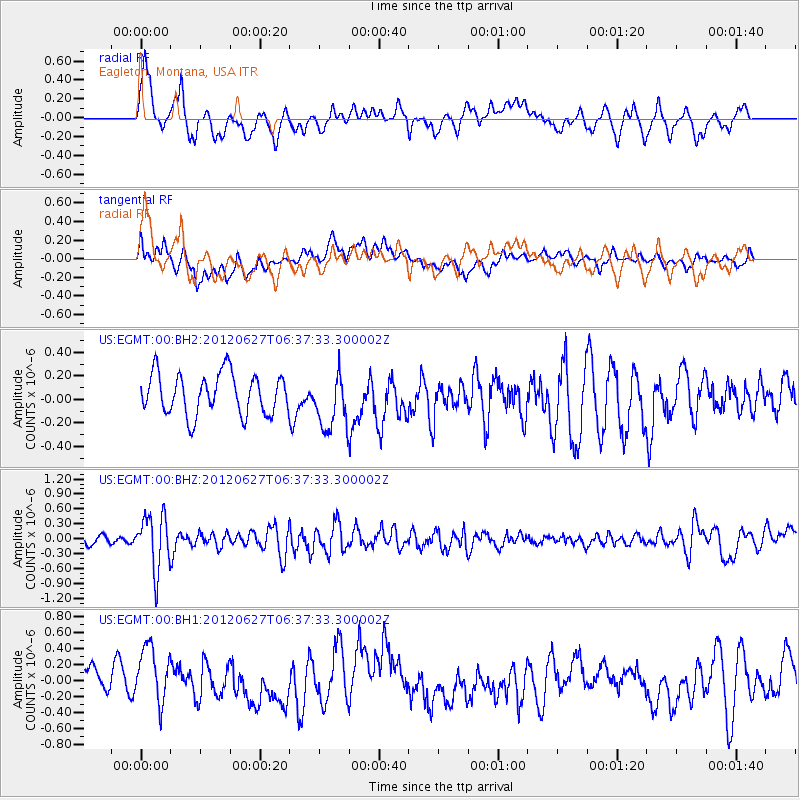
Signal To Noise
| Channel | StoN | STA | LTA |
| US:EGMT:00:BHZ:20120627T06:37:33.300002Z | 5.95279 | 5.535596E-7 | 9.299162E-8 |
| US:EGMT:00:BH1:20120627T06:37:33.300002Z | 2.1782057 | 4.2540225E-7 | 1.9529939E-7 |
| US:EGMT:00:BH2:20120627T06:37:33.300002Z | 1.3897344 | 2.3917806E-7 | 1.7210343E-7 |
| Arrivals |
| Ps | |
| PpPs | |
| PsPs/PpSs | |


