You are here: Home > Network List > US - United States National Seismic Network Stations List
> Station HAWA Hanford, Washington, USA > Earthquake Result Viewer
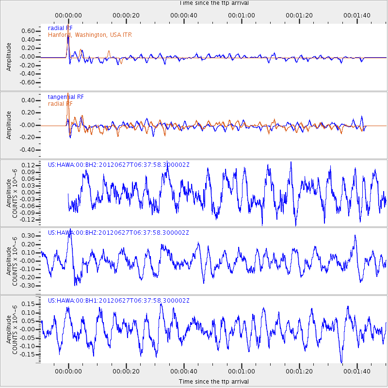
HAWA Hanford, Washington, USA - Earthquake Result Viewer
*The percent match for this event was below the threshold and hence no stack was calculated.
| Earthquake location: |
El Salvador |
| Earthquake latitude/longitude: |
13.8/-90.0 |
| Earthquake time(UTC): |
2012/06/27 (179) 06:30:59 GMT |
| Earthquake Depth: |
133 km |
| Earthquake Magnitude: |
5.7 MW, 5.4 MB, 5.7 MW |
| Earthquake Catalog/Contributor: |
WHDF/NEIC |
|
| Network: |
US United States National Seismic Network |
| Station: |
HAWA Hanford, Washington, USA |
| Lat/Lon: |
46.39 N/119.53 W |
| Elevation: |
364 m |
|
| Distance: |
40.9 deg |
| Az: |
328.534 deg |
| Baz: |
132.898 deg |
| Ray Param: |
$rayparam |
*The percent match for this event was below the threshold and hence was not used in the summary stack. |
|
| Radial Match: |
59.597572 % |
| Radial Bump: |
400 |
| Transverse Match: |
52.562542 % |
| Transverse Bump: |
400 |
| SOD ConfigId: |
558545 |
| Insert Time: |
2013-09-19 21:21:17.487 +0000 |
| GWidth: |
2.5 |
| Max Bumps: |
400 |
| Tol: |
0.001 |
|
Signal To Noise
| Channel | StoN | STA | LTA |
| US:HAWA:00:BHZ:20120627T06:37:58.300002Z | 3.1159754 | 2.1759847E-7 | 6.983318E-8 |
| US:HAWA:00:BH1:20120627T06:37:58.300002Z | 2.178164 | 6.746591E-8 | 3.0973755E-8 |
| US:HAWA:00:BH2:20120627T06:37:58.300002Z | 1.6957152 | 7.195505E-8 | 4.2433452E-8 |
| Arrivals |
| Ps | |
| PpPs | |
| PsPs/PpSs | |


