You are here: Home > Network List > US - United States National Seismic Network Stations List
> Station HLID Hailey, Idaho, USA > Earthquake Result Viewer
HLID Hailey, Idaho, USA - Earthquake Result Viewer
*The percent match for this event was below the threshold and hence no stack was calculated.
| Earthquake location: |
Tonga Islands |
| Earthquake latitude/longitude: |
-15.2/-173.3 |
| Earthquake time(UTC): |
2012/06/27 (179) 20:39:15 GMT |
| Earthquake Depth: |
10 km |
| Earthquake Magnitude: |
5.5 MW |
| Earthquake Catalog/Contributor: |
NEIC PDE/NEIC PDE-M |
|
| Network: |
US United States National Seismic Network |
| Station: |
HLID Hailey, Idaho, USA |
| Lat/Lon: |
43.56 N/114.41 W |
| Elevation: |
1772 m |
|
| Distance: |
79.4 deg |
| Az: |
39.266 deg |
| Baz: |
237.195 deg |
| Ray Param: |
$rayparam |
*The percent match for this event was below the threshold and hence was not used in the summary stack. |
|
| Radial Match: |
53.044136 % |
| Radial Bump: |
400 |
| Transverse Match: |
39.113815 % |
| Transverse Bump: |
400 |
| SOD ConfigId: |
558545 |
| Insert Time: |
2013-09-19 21:23:39.166 +0000 |
| GWidth: |
2.5 |
| Max Bumps: |
400 |
| Tol: |
0.001 |
|
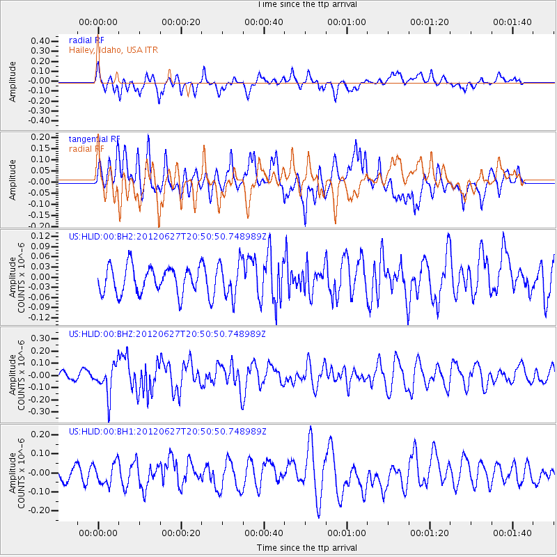
Signal To Noise
| Channel | StoN | STA | LTA |
| US:HLID:00:BHZ:20120627T20:50:50.748989Z | 3.1587338 | 1.3126565E-7 | 4.155641E-8 |
| US:HLID:00:BH1:20120627T20:50:50.748989Z | 0.88378584 | 5.750171E-8 | 6.506294E-8 |
| US:HLID:00:BH2:20120627T20:50:50.748989Z | 1.3663228 | 5.2632068E-8 | 3.8520966E-8 |
| Arrivals |
| Ps | |
| PpPs | |
| PsPs/PpSs | |


