You are here: Home > Network List > CU - Caribbean Network (USGS) Stations List
> Station GTBY Guantanamo Bay, Cuba > Earthquake Result Viewer
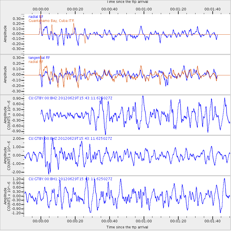
GTBY Guantanamo Bay, Cuba - Earthquake Result Viewer
*The percent match for this event was below the threshold and hence no stack was calculated.
| Earthquake location: |
South Atlantic Ocean |
| Earthquake latitude/longitude: |
-24.7/-9.7 |
| Earthquake time(UTC): |
2012/06/29 (181) 15:31:46 GMT |
| Earthquake Depth: |
10 km |
| Earthquake Magnitude: |
6.0 MB, 5.2 MS, 5.8 MW, 5.8 MW |
| Earthquake Catalog/Contributor: |
WHDF/NEIC |
|
| Network: |
CU Caribbean Network (USGS) |
| Station: |
GTBY Guantanamo Bay, Cuba |
| Lat/Lon: |
19.93 N/75.11 W |
| Elevation: |
79 m |
|
| Distance: |
77.6 deg |
| Az: |
298.817 deg |
| Baz: |
122.144 deg |
| Ray Param: |
$rayparam |
*The percent match for this event was below the threshold and hence was not used in the summary stack. |
|
| Radial Match: |
55.028473 % |
| Radial Bump: |
400 |
| Transverse Match: |
67.863655 % |
| Transverse Bump: |
400 |
| SOD ConfigId: |
558545 |
| Insert Time: |
2013-09-19 21:24:46.124 +0000 |
| GWidth: |
2.5 |
| Max Bumps: |
400 |
| Tol: |
0.001 |
|
Signal To Noise
| Channel | StoN | STA | LTA |
| CU:GTBY:00:BHZ:20120629T15:43:11.625027Z | 3.6947808 | 1.0826252E-6 | 2.9301472E-7 |
| CU:GTBY:00:BH1:20120629T15:43:11.625027Z | 1.2290521 | 3.8800766E-7 | 3.156967E-7 |
| CU:GTBY:00:BH2:20120629T15:43:11.625027Z | 3.3442817 | 4.1990518E-7 | 1.2555915E-7 |
| Arrivals |
| Ps | |
| PpPs | |
| PsPs/PpSs | |


