You are here: Home > Network List > IU - Global Seismograph Network (GSN - IRIS/USGS) Stations List
> Station OTAV Otavalo, Ecuador > Earthquake Result Viewer
OTAV Otavalo, Ecuador - Earthquake Result Viewer
| Earthquake location: |
South Atlantic Ocean |
| Earthquake latitude/longitude: |
-24.7/-9.7 |
| Earthquake time(UTC): |
2012/06/29 (181) 15:31:46 GMT |
| Earthquake Depth: |
10 km |
| Earthquake Magnitude: |
6.0 MB, 5.2 MS, 5.8 MW, 5.8 MW |
| Earthquake Catalog/Contributor: |
WHDF/NEIC |
|
| Network: |
IU Global Seismograph Network (GSN - IRIS/USGS) |
| Station: |
OTAV Otavalo, Ecuador |
| Lat/Lon: |
0.24 N/78.45 W |
| Elevation: |
3510 m |
|
| Distance: |
70.9 deg |
| Az: |
279.402 deg |
| Baz: |
116.231 deg |
| Ray Param: |
0.054678436 |
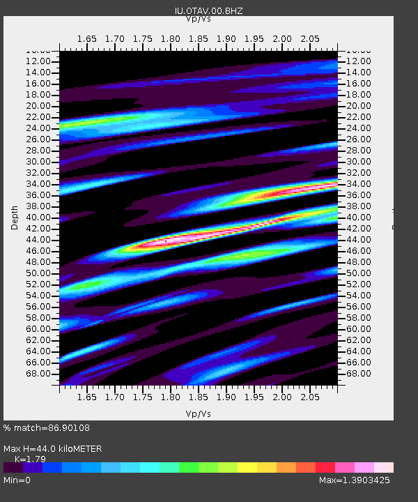
| Estimated Moho Depth: |
44.0 km |
| Estimated Crust Vp/Vs: |
1.79 |
| Assumed Crust Vp: |
6.472 km/s |
| Estimated Crust Vs: |
3.616 km/s |
| Estimated Crust Poisson's Ratio: |
0.27 |
|
| Radial Match: |
86.90108 % |
| Radial Bump: |
400 |
| Transverse Match: |
86.76765 % |
| Transverse Bump: |
400 |
| SOD ConfigId: |
558545 |
| Insert Time: |
2013-09-19 21:25:45.861 +0000 |
| GWidth: |
2.5 |
| Max Bumps: |
400 |
| Tol: |
0.001 |
|
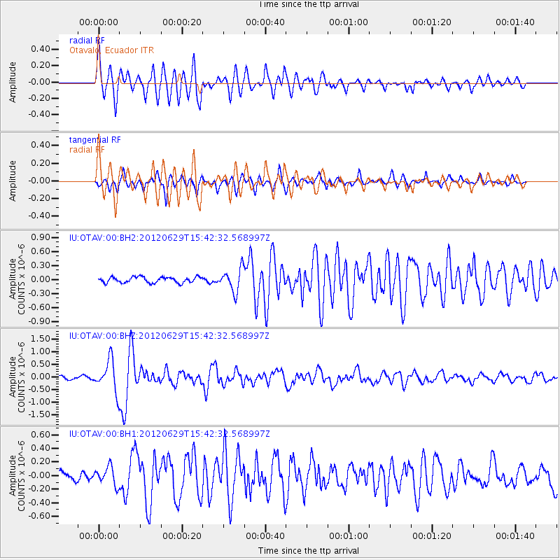
Signal To Noise
| Channel | StoN | STA | LTA |
| IU:OTAV:00:BHZ:20120629T15:42:32.568997Z | 9.785795 | 6.44804E-7 | 6.589184E-8 |
| IU:OTAV:00:BH1:20120629T15:42:32.568997Z | 2.7304788 | 1.392829E-7 | 5.101043E-8 |
| IU:OTAV:00:BH2:20120629T15:42:32.568997Z | 4.160819 | 2.5363246E-7 | 6.095734E-8 |
| Arrivals |
| Ps | 5.6 SECOND |
| PpPs | 18 SECOND |
| PsPs/PpSs | 24 SECOND |


