You are here: Home > Network List > IU - Global Seismograph Network (GSN - IRIS/USGS) Stations List
> Station PMG Port Moresby, New Guinea > Earthquake Result Viewer
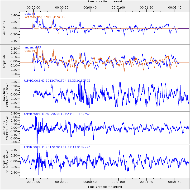
PMG Port Moresby, New Guinea - Earthquake Result Viewer
*The percent match for this event was below the threshold and hence no stack was calculated.
| Earthquake location: |
Myanmar-India Border Region |
| Earthquake latitude/longitude: |
25.6/94.7 |
| Earthquake time(UTC): |
2012/07/01 (183) 04:13:52 GMT |
| Earthquake Depth: |
58 km |
| Earthquake Magnitude: |
5.5 MB, 5.6 MW, 5.6 MW |
| Earthquake Catalog/Contributor: |
WHDF/NEIC |
|
| Network: |
IU Global Seismograph Network (GSN - IRIS/USGS) |
| Station: |
PMG Port Moresby, New Guinea |
| Lat/Lon: |
9.40 S/147.16 E |
| Elevation: |
90 m |
|
| Distance: |
61.8 deg |
| Az: |
117.359 deg |
| Baz: |
305.63 deg |
| Ray Param: |
$rayparam |
*The percent match for this event was below the threshold and hence was not used in the summary stack. |
|
| Radial Match: |
46.27091 % |
| Radial Bump: |
400 |
| Transverse Match: |
60.772915 % |
| Transverse Bump: |
400 |
| SOD ConfigId: |
558545 |
| Insert Time: |
2013-09-19 21:33:35.083 +0000 |
| GWidth: |
2.5 |
| Max Bumps: |
400 |
| Tol: |
0.001 |
|
Signal To Noise
| Channel | StoN | STA | LTA |
| IU:PMG:00:BHZ:20120701T04:23:33.918979Z | 3.5742579 | 3.0322576E-7 | 8.4836E-8 |
| IU:PMG:00:BH1:20120701T04:23:33.918979Z | 2.2253423 | 2.1087071E-7 | 9.475878E-8 |
| IU:PMG:00:BH2:20120701T04:23:33.918979Z | 1.654484 | 1.375815E-7 | 8.3156735E-8 |
| Arrivals |
| Ps | |
| PpPs | |
| PsPs/PpSs | |


