You are here: Home > Network List > IU - Global Seismograph Network (GSN - IRIS/USGS) Stations List
> Station PMG Port Moresby, New Guinea > Earthquake Result Viewer
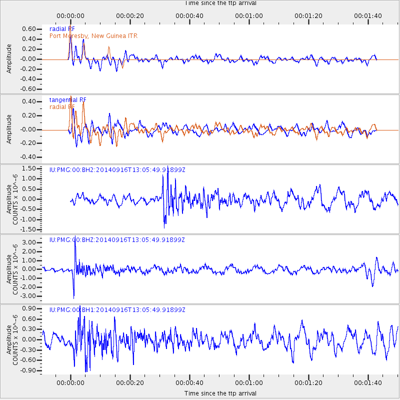
PMG Port Moresby, New Guinea - Earthquake Result Viewer
*The percent match for this event was below the threshold and hence no stack was calculated.
| Earthquake location: |
South Of Fiji Islands |
| Earthquake latitude/longitude: |
-22.3/-179.5 |
| Earthquake time(UTC): |
2014/09/16 (259) 13:00:20 GMT |
| Earthquake Depth: |
585 km |
| Earthquake Magnitude: |
5.5 MW |
| Earthquake Catalog/Contributor: |
ISC/ISC |
|
| Network: |
IU Global Seismograph Network (GSN - IRIS/USGS) |
| Station: |
PMG Port Moresby, New Guinea |
| Lat/Lon: |
9.40 S/147.16 E |
| Elevation: |
90 m |
|
| Distance: |
34.5 deg |
| Az: |
286.485 deg |
| Baz: |
115.848 deg |
| Ray Param: |
$rayparam |
*The percent match for this event was below the threshold and hence was not used in the summary stack. |
|
| Radial Match: |
62.759804 % |
| Radial Bump: |
400 |
| Transverse Match: |
74.13244 % |
| Transverse Bump: |
400 |
| SOD ConfigId: |
3390531 |
| Insert Time: |
2019-04-14 02:09:25.320 +0000 |
| GWidth: |
2.5 |
| Max Bumps: |
400 |
| Tol: |
0.001 |
|
Signal To Noise
| Channel | StoN | STA | LTA |
| IU:PMG:00:BHZ:20140916T13:05:49.91899Z | 6.8594832 | 1.0865047E-6 | 1.5839453E-7 |
| IU:PMG:00:BH1:20140916T13:05:49.91899Z | 2.4680638 | 3.6562648E-7 | 1.4814304E-7 |
| IU:PMG:00:BH2:20140916T13:05:49.91899Z | 4.0070825 | 6.3174605E-7 | 1.5765735E-7 |
| Arrivals |
| Ps | |
| PpPs | |
| PsPs/PpSs | |


