You are here: Home > Network List > US - United States National Seismic Network Stations List
> Station HDIL Hopedale, Illinois, USA > Earthquake Result Viewer
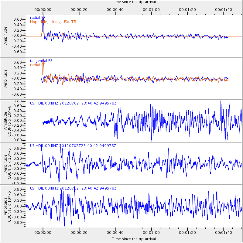
HDIL Hopedale, Illinois, USA - Earthquake Result Viewer
*The percent match for this event was below the threshold and hence no stack was calculated.
| Earthquake location: |
Near Coast Of Peru |
| Earthquake latitude/longitude: |
-14.4/-75.6 |
| Earthquake time(UTC): |
2012/07/02 (184) 23:31:37 GMT |
| Earthquake Depth: |
40 km |
| Earthquake Magnitude: |
6.0 MB, 5.2 MS, 5.7 MW, 5.6 MW |
| Earthquake Catalog/Contributor: |
WHDF/NEIC |
|
| Network: |
US United States National Seismic Network |
| Station: |
HDIL Hopedale, Illinois, USA |
| Lat/Lon: |
40.56 N/89.29 W |
| Elevation: |
219 m |
|
| Distance: |
56.2 deg |
| Az: |
347.455 deg |
| Baz: |
163.966 deg |
| Ray Param: |
$rayparam |
*The percent match for this event was below the threshold and hence was not used in the summary stack. |
|
| Radial Match: |
76.94726 % |
| Radial Bump: |
400 |
| Transverse Match: |
66.48543 % |
| Transverse Bump: |
400 |
| SOD ConfigId: |
558545 |
| Insert Time: |
2013-09-19 21:36:55.543 +0000 |
| GWidth: |
2.5 |
| Max Bumps: |
400 |
| Tol: |
0.001 |
|
Signal To Noise
| Channel | StoN | STA | LTA |
| US:HDIL:00:BHZ:20120702T23:40:42.949978Z | 7.7604346 | 4.2952556E-7 | 5.534813E-8 |
| US:HDIL:00:BH1:20120702T23:40:42.949978Z | 3.5654006 | 3.2012403E-7 | 8.9786276E-8 |
| US:HDIL:00:BH2:20120702T23:40:42.949978Z | 1.7888833 | 1.7471191E-7 | 9.766534E-8 |
| Arrivals |
| Ps | |
| PpPs | |
| PsPs/PpSs | |


