You are here: Home > Network List > TA - USArray Transportable Network (new EarthScope stations) Stations List
> Station L04D Klamath Falls, OR, USA > Earthquake Result Viewer
L04D Klamath Falls, OR, USA - Earthquake Result Viewer
*The percent match for this event was below the threshold and hence no stack was calculated.
| Earthquake location: |
South Of Fiji Islands |
| Earthquake latitude/longitude: |
-22.3/-179.5 |
| Earthquake time(UTC): |
2014/09/16 (259) 13:00:20 GMT |
| Earthquake Depth: |
585 km |
| Earthquake Magnitude: |
5.5 MW |
| Earthquake Catalog/Contributor: |
ISC/ISC |
|
| Network: |
TA USArray Transportable Network (new EarthScope stations) |
| Station: |
L04D Klamath Falls, OR, USA |
| Lat/Lon: |
42.22 N/122.30 W |
| Elevation: |
1437 m |
|
| Distance: |
83.1 deg |
| Az: |
38.958 deg |
| Baz: |
231.615 deg |
| Ray Param: |
$rayparam |
*The percent match for this event was below the threshold and hence was not used in the summary stack. |
|
| Radial Match: |
56.097816 % |
| Radial Bump: |
400 |
| Transverse Match: |
56.95854 % |
| Transverse Bump: |
400 |
| SOD ConfigId: |
3390531 |
| Insert Time: |
2019-04-14 02:10:41.825 +0000 |
| GWidth: |
2.5 |
| Max Bumps: |
400 |
| Tol: |
0.001 |
|
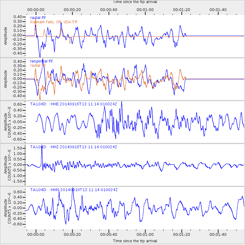
Signal To Noise
| Channel | StoN | STA | LTA |
| TA:L04D: :HHZ:20140916T13:11:14.010024Z | 4.4420743 | 4.603008E-7 | 1.0362294E-7 |
| TA:L04D: :HHN:20140916T13:11:14.010024Z | 0.9983032 | 1.6646541E-7 | 1.6674835E-7 |
| TA:L04D: :HHE:20140916T13:11:14.010024Z | 1.3874569 | 2.7507872E-7 | 1.9826109E-7 |
| Arrivals |
| Ps | |
| PpPs | |
| PsPs/PpSs | |


