You are here: Home > Network List > US - United States National Seismic Network Stations List
> Station MSO Missoula, Montana, USA > Earthquake Result Viewer
MSO Missoula, Montana, USA - Earthquake Result Viewer
*The percent match for this event was below the threshold and hence no stack was calculated.
| Earthquake location: |
Solomon Islands |
| Earthquake latitude/longitude: |
-10.8/163.3 |
| Earthquake time(UTC): |
2012/07/03 (185) 03:49:33 GMT |
| Earthquake Depth: |
92 km |
| Earthquake Magnitude: |
5.6 MB, 5.5 MW, 5.5 MW |
| Earthquake Catalog/Contributor: |
WHDF/NEIC |
|
| Network: |
US United States National Seismic Network |
| Station: |
MSO Missoula, Montana, USA |
| Lat/Lon: |
46.83 N/113.94 W |
| Elevation: |
1264 m |
|
| Distance: |
92.9 deg |
| Az: |
42.997 deg |
| Baz: |
257.365 deg |
| Ray Param: |
$rayparam |
*The percent match for this event was below the threshold and hence was not used in the summary stack. |
|
| Radial Match: |
49.11444 % |
| Radial Bump: |
400 |
| Transverse Match: |
51.40682 % |
| Transverse Bump: |
400 |
| SOD ConfigId: |
558545 |
| Insert Time: |
2013-09-19 21:40:31.093 +0000 |
| GWidth: |
2.5 |
| Max Bumps: |
400 |
| Tol: |
0.001 |
|
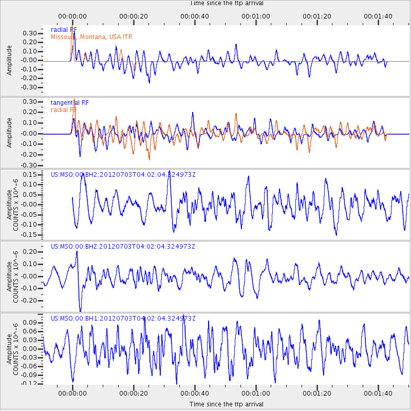
Signal To Noise
| Channel | StoN | STA | LTA |
| US:MSO:00:BHZ:20120703T04:02:04.324973Z | 2.1420062 | 1.3664287E-7 | 6.379201E-8 |
| US:MSO:00:BH1:20120703T04:02:04.324973Z | 1.259793 | 5.314929E-8 | 4.2188905E-8 |
| US:MSO:00:BH2:20120703T04:02:04.324973Z | 1.4587268 | 8.531379E-8 | 5.8485107E-8 |
| Arrivals |
| Ps | |
| PpPs | |
| PsPs/PpSs | |


