You are here: Home > Network List > IU - Global Seismograph Network (GSN - IRIS/USGS) Stations List
> Station HNR Honiara, Solomon Islands > Earthquake Result Viewer
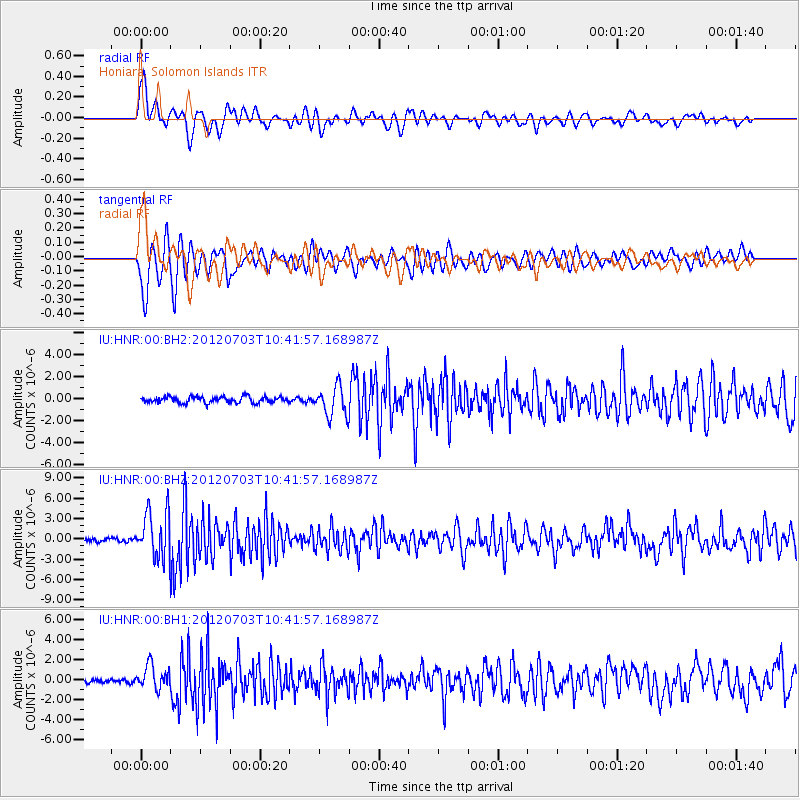
HNR Honiara, Solomon Islands - Earthquake Result Viewer
*The percent match for this event was below the threshold and hence no stack was calculated.
| Earthquake location: |
Cook Strait, New Zealand |
| Earthquake latitude/longitude: |
-40.0/173.8 |
| Earthquake time(UTC): |
2012/07/03 (185) 10:36:15 GMT |
| Earthquake Depth: |
230 km |
| Earthquake Magnitude: |
5.9 MB, 6.3 MW, 6.3 MW |
| Earthquake Catalog/Contributor: |
WHDF/NEIC |
|
| Network: |
IU Global Seismograph Network (GSN - IRIS/USGS) |
| Station: |
HNR Honiara, Solomon Islands |
| Lat/Lon: |
9.44 S/159.95 E |
| Elevation: |
100 m |
|
| Distance: |
32.8 deg |
| Az: |
334.269 deg |
| Baz: |
160.251 deg |
| Ray Param: |
$rayparam |
*The percent match for this event was below the threshold and hence was not used in the summary stack. |
|
| Radial Match: |
70.13358 % |
| Radial Bump: |
400 |
| Transverse Match: |
73.732765 % |
| Transverse Bump: |
400 |
| SOD ConfigId: |
558545 |
| Insert Time: |
2013-09-19 21:42:00.155 +0000 |
| GWidth: |
2.5 |
| Max Bumps: |
400 |
| Tol: |
0.001 |
|
Signal To Noise
| Channel | StoN | STA | LTA |
| IU:HNR:00:BHZ:20120703T10:41:57.168987Z | 13.628553 | 3.5091873E-6 | 2.5748787E-7 |
| IU:HNR:00:BH1:20120703T10:41:57.168987Z | 4.4950104 | 1.1868351E-6 | 2.640339E-7 |
| IU:HNR:00:BH2:20120703T10:41:57.168987Z | 4.7285795 | 1.3209171E-6 | 2.7934755E-7 |
| Arrivals |
| Ps | |
| PpPs | |
| PsPs/PpSs | |


