You are here: Home > Network List > IU - Global Seismograph Network (GSN - IRIS/USGS) Stations List
> Station JOHN Johnston Island, USA > Earthquake Result Viewer
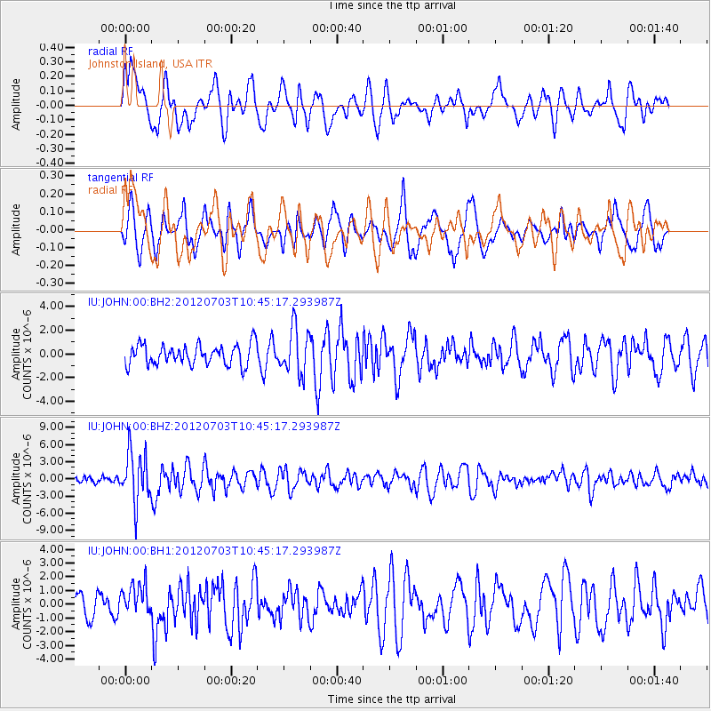
JOHN Johnston Island, USA - Earthquake Result Viewer
*The percent match for this event was below the threshold and hence no stack was calculated.
| Earthquake location: |
Cook Strait, New Zealand |
| Earthquake latitude/longitude: |
-40.0/173.8 |
| Earthquake time(UTC): |
2012/07/03 (185) 10:36:15 GMT |
| Earthquake Depth: |
230 km |
| Earthquake Magnitude: |
5.9 MB, 6.3 MW, 6.3 MW |
| Earthquake Catalog/Contributor: |
WHDF/NEIC |
|
| Network: |
IU Global Seismograph Network (GSN - IRIS/USGS) |
| Station: |
JOHN Johnston Island, USA |
| Lat/Lon: |
16.73 N/169.53 W |
| Elevation: |
2.0 m |
|
| Distance: |
58.6 deg |
| Az: |
18.842 deg |
| Baz: |
195.0 deg |
| Ray Param: |
$rayparam |
*The percent match for this event was below the threshold and hence was not used in the summary stack. |
|
| Radial Match: |
68.4041 % |
| Radial Bump: |
400 |
| Transverse Match: |
64.86671 % |
| Transverse Bump: |
400 |
| SOD ConfigId: |
558545 |
| Insert Time: |
2013-09-19 21:42:05.680 +0000 |
| GWidth: |
2.5 |
| Max Bumps: |
400 |
| Tol: |
0.001 |
|
Signal To Noise
| Channel | StoN | STA | LTA |
| IU:JOHN:00:BHZ:20120703T10:45:17.293987Z | 4.9611783 | 4.402138E-6 | 8.8731707E-7 |
| IU:JOHN:00:BH1:20120703T10:45:17.293987Z | 1.3664197 | 1.1840322E-6 | 8.665216E-7 |
| IU:JOHN:00:BH2:20120703T10:45:17.293987Z | 2.2529294 | 1.9319543E-6 | 8.575298E-7 |
| Arrivals |
| Ps | |
| PpPs | |
| PsPs/PpSs | |


