You are here: Home > Network List > US - United States National Seismic Network Stations List
> Station HAWA Hanford, Washington, USA > Earthquake Result Viewer
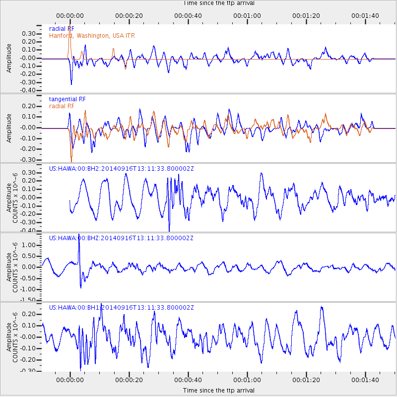
HAWA Hanford, Washington, USA - Earthquake Result Viewer
*The percent match for this event was below the threshold and hence no stack was calculated.
| Earthquake location: |
South Of Fiji Islands |
| Earthquake latitude/longitude: |
-22.3/-179.5 |
| Earthquake time(UTC): |
2014/09/16 (259) 13:00:20 GMT |
| Earthquake Depth: |
585 km |
| Earthquake Magnitude: |
5.5 MW |
| Earthquake Catalog/Contributor: |
ISC/ISC |
|
| Network: |
US United States National Seismic Network |
| Station: |
HAWA Hanford, Washington, USA |
| Lat/Lon: |
46.39 N/119.53 W |
| Elevation: |
364 m |
|
| Distance: |
87.2 deg |
| Az: |
36.853 deg |
| Baz: |
233.368 deg |
| Ray Param: |
$rayparam |
*The percent match for this event was below the threshold and hence was not used in the summary stack. |
|
| Radial Match: |
63.594166 % |
| Radial Bump: |
400 |
| Transverse Match: |
57.08846 % |
| Transverse Bump: |
400 |
| SOD ConfigId: |
3390531 |
| Insert Time: |
2019-04-14 02:11:10.293 +0000 |
| GWidth: |
2.5 |
| Max Bumps: |
400 |
| Tol: |
0.001 |
|
Signal To Noise
| Channel | StoN | STA | LTA |
| US:HAWA:00:BHZ:20140916T13:11:33.800002Z | 2.0746105 | 4.6908755E-7 | 2.2610872E-7 |
| US:HAWA:00:BH1:20140916T13:11:33.800002Z | 0.6665344 | 9.24142E-8 | 1.386488E-7 |
| US:HAWA:00:BH2:20140916T13:11:33.800002Z | 1.0300766 | 1.6289843E-7 | 1.5814204E-7 |
| Arrivals |
| Ps | |
| PpPs | |
| PsPs/PpSs | |


