You are here: Home > Network List > AU - Australian Seismological Centre Stations List
> Station PSAC2 Pilbara Seismic Array Element C2 > Earthquake Result Viewer
PSAC2 Pilbara Seismic Array Element C2 - Earthquake Result Viewer
| Earthquake location: |
Vanuatu Islands |
| Earthquake latitude/longitude: |
-14.7/167.3 |
| Earthquake time(UTC): |
2012/07/06 (188) 02:28:22 GMT |
| Earthquake Depth: |
160 km |
| Earthquake Magnitude: |
5.7 MB, 6.3 MW, 6.3 MW |
| Earthquake Catalog/Contributor: |
WHDF/NEIC |
|
| Network: |
AU Australian Seismological Centre |
| Station: |
PSAC2 Pilbara Seismic Array Element C2 |
| Lat/Lon: |
21.56 S/119.90 E |
| Elevation: |
330 m |
|
| Distance: |
45.5 deg |
| Az: |
254.098 deg |
| Baz: |
89.587 deg |
| Ray Param: |
0.07067083 |
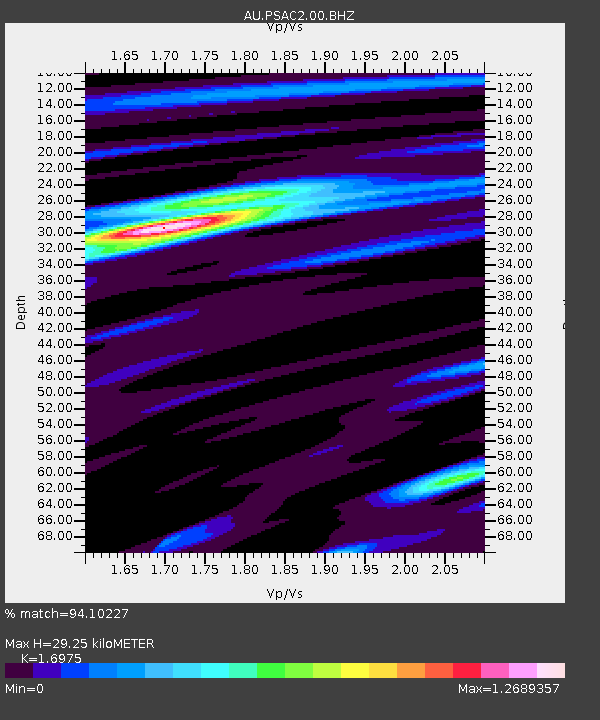
| Estimated Moho Depth: |
29.25 km |
| Estimated Crust Vp/Vs: |
1.70 |
| Assumed Crust Vp: |
6.464 km/s |
| Estimated Crust Vs: |
3.808 km/s |
| Estimated Crust Poisson's Ratio: |
0.23 |
|
| Radial Match: |
94.10227 % |
| Radial Bump: |
291 |
| Transverse Match: |
74.35006 % |
| Transverse Bump: |
400 |
| SOD ConfigId: |
558545 |
| Insert Time: |
2013-09-19 21:43:27.928 +0000 |
| GWidth: |
2.5 |
| Max Bumps: |
400 |
| Tol: |
0.001 |
|

Signal To Noise
| Channel | StoN | STA | LTA |
| AU:PSAC2:00:BHZ:20120706T02:35:54.818998Z | 7.787001 | 2.247156E-6 | 2.8857787E-7 |
| AU:PSAC2:00:BH1:20120706T02:35:54.818998Z | 8.390131 | 1.2073806E-6 | 1.4390484E-7 |
| AU:PSAC2:00:BH2:20120706T02:35:54.818998Z | 2.417571 | 5.5146404E-7 | 2.2810663E-7 |
| Arrivals |
| Ps | 3.4 SECOND |
| PpPs | 11 SECOND |
| PsPs/PpSs | 15 SECOND |


