You are here: Home > Network List > US - United States National Seismic Network Stations List
> Station MSO Missoula, Montana, USA > Earthquake Result Viewer
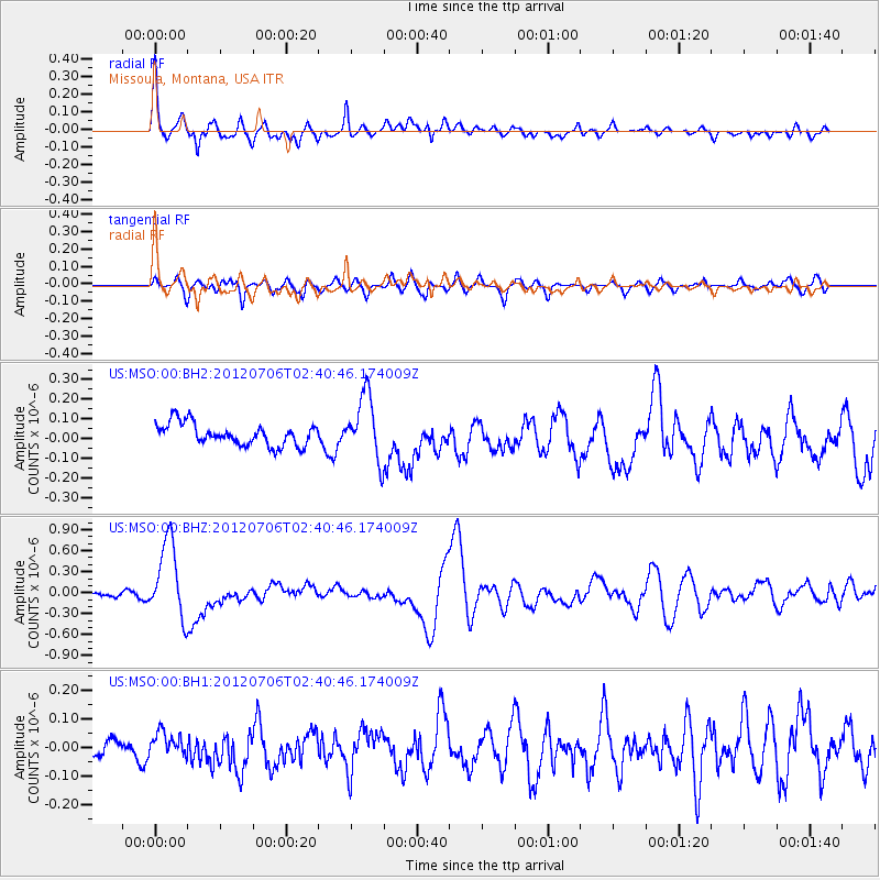
MSO Missoula, Montana, USA - Earthquake Result Viewer
*The percent match for this event was below the threshold and hence no stack was calculated.
| Earthquake location: |
Vanuatu Islands |
| Earthquake latitude/longitude: |
-14.7/167.3 |
| Earthquake time(UTC): |
2012/07/06 (188) 02:28:22 GMT |
| Earthquake Depth: |
160 km |
| Earthquake Magnitude: |
5.7 MB, 6.3 MW, 6.3 MW |
| Earthquake Catalog/Contributor: |
WHDF/NEIC |
|
| Network: |
US United States National Seismic Network |
| Station: |
MSO Missoula, Montana, USA |
| Lat/Lon: |
46.83 N/113.94 W |
| Elevation: |
1264 m |
|
| Distance: |
93.0 deg |
| Az: |
42.399 deg |
| Baz: |
251.897 deg |
| Ray Param: |
$rayparam |
*The percent match for this event was below the threshold and hence was not used in the summary stack. |
|
| Radial Match: |
76.64635 % |
| Radial Bump: |
400 |
| Transverse Match: |
68.075745 % |
| Transverse Bump: |
400 |
| SOD ConfigId: |
558545 |
| Insert Time: |
2013-09-19 21:45:09.529 +0000 |
| GWidth: |
2.5 |
| Max Bumps: |
400 |
| Tol: |
0.001 |
|
Signal To Noise
| Channel | StoN | STA | LTA |
| US:MSO:00:BHZ:20120706T02:40:46.174009Z | 13.092026 | 5.5440313E-7 | 4.2346628E-8 |
| US:MSO:00:BH1:20120706T02:40:46.174009Z | 0.59085363 | 3.5819117E-8 | 6.0622654E-8 |
| US:MSO:00:BH2:20120706T02:40:46.174009Z | 2.96787 | 1.6434333E-7 | 5.537417E-8 |
| Arrivals |
| Ps | |
| PpPs | |
| PsPs/PpSs | |


