You are here: Home > Network List > II - Global Seismograph Network (GSN - IRIS/IDA) Stations List
> Station WRAB Tennant Creek, NT, Australia > Earthquake Result Viewer
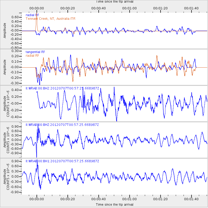
WRAB Tennant Creek, NT, Australia - Earthquake Result Viewer
*The percent match for this event was below the threshold and hence no stack was calculated.
| Earthquake location: |
North Island, New Zealand |
| Earthquake latitude/longitude: |
-39.1/175.8 |
| Earthquake time(UTC): |
2012/07/07 (189) 00:50:27 GMT |
| Earthquake Depth: |
91 km |
| Earthquake Magnitude: |
5.7 ML |
| Earthquake Catalog/Contributor: |
NEIC PDE/NEIC PDE-M |
|
| Network: |
II Global Seismograph Network (GSN - IRIS/IDA) |
| Station: |
WRAB Tennant Creek, NT, Australia |
| Lat/Lon: |
19.93 S/134.36 E |
| Elevation: |
366 m |
|
| Distance: |
40.4 deg |
| Az: |
286.021 deg |
| Baz: |
127.317 deg |
| Ray Param: |
$rayparam |
*The percent match for this event was below the threshold and hence was not used in the summary stack. |
|
| Radial Match: |
55.93398 % |
| Radial Bump: |
400 |
| Transverse Match: |
53.825966 % |
| Transverse Bump: |
383 |
| SOD ConfigId: |
558545 |
| Insert Time: |
2013-09-19 21:46:04.235 +0000 |
| GWidth: |
2.5 |
| Max Bumps: |
400 |
| Tol: |
0.001 |
|
Signal To Noise
| Channel | StoN | STA | LTA |
| II:WRAB:00:BHZ:20120707T00:57:25.668987Z | 2.0671744 | 4.3209923E-7 | 2.0902893E-7 |
| II:WRAB:00:BH1:20120707T00:57:25.668987Z | 2.0878808 | 4.2436758E-7 | 2.0325278E-7 |
| II:WRAB:00:BH2:20120707T00:57:25.668987Z | 0.88432556 | 1.5834094E-7 | 1.7905278E-7 |
| Arrivals |
| Ps | |
| PpPs | |
| PsPs/PpSs | |


