You are here: Home > Network List > US - United States National Seismic Network Stations List
> Station DGMT Dagmar, Montana, USA > Earthquake Result Viewer
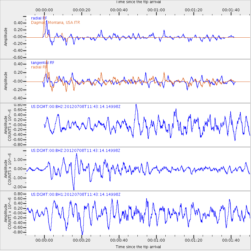
DGMT Dagmar, Montana, USA - Earthquake Result Viewer
*The percent match for this event was below the threshold and hence no stack was calculated.
| Earthquake location: |
Kuril Islands |
| Earthquake latitude/longitude: |
45.5/151.3 |
| Earthquake time(UTC): |
2012/07/08 (190) 11:33:02 GMT |
| Earthquake Depth: |
20 km |
| Earthquake Magnitude: |
5.7 MB, 5.6 MS, 6.0 MW, 5.8 MW |
| Earthquake Catalog/Contributor: |
WHDF/NEIC |
|
| Network: |
US United States National Seismic Network |
| Station: |
DGMT Dagmar, Montana, USA |
| Lat/Lon: |
48.47 N/104.20 W |
| Elevation: |
0.0 m |
|
| Distance: |
65.6 deg |
| Az: |
45.031 deg |
| Baz: |
311.607 deg |
| Ray Param: |
$rayparam |
*The percent match for this event was below the threshold and hence was not used in the summary stack. |
|
| Radial Match: |
83.276764 % |
| Radial Bump: |
400 |
| Transverse Match: |
66.97294 % |
| Transverse Bump: |
400 |
| SOD ConfigId: |
558545 |
| Insert Time: |
2013-09-19 21:51:36.517 +0000 |
| GWidth: |
2.5 |
| Max Bumps: |
400 |
| Tol: |
0.001 |
|
Signal To Noise
| Channel | StoN | STA | LTA |
| US:DGMT:00:BHZ:20120708T11:43:14.14998Z | 5.10429 | 5.3914636E-7 | 1.0562613E-7 |
| US:DGMT:00:BH1:20120708T11:43:14.14998Z | 2.6845152 | 3.337487E-7 | 1.2432363E-7 |
| US:DGMT:00:BH2:20120708T11:43:14.14998Z | 0.7875374 | 1.3931509E-7 | 1.7689965E-7 |
| Arrivals |
| Ps | |
| PpPs | |
| PsPs/PpSs | |


