You are here: Home > Network List > US - United States National Seismic Network Stations List
> Station MSO Missoula, Montana, USA > Earthquake Result Viewer
MSO Missoula, Montana, USA - Earthquake Result Viewer
*The percent match for this event was below the threshold and hence no stack was calculated.
| Earthquake location: |
Eastern Mediterranean Sea |
| Earthquake latitude/longitude: |
35.6/28.9 |
| Earthquake time(UTC): |
2012/07/09 (191) 13:55:00 GMT |
| Earthquake Depth: |
56 km |
| Earthquake Magnitude: |
5.6 MB, 5.6 MW, 5.6 MW |
| Earthquake Catalog/Contributor: |
WHDF/NEIC |
|
| Network: |
US United States National Seismic Network |
| Station: |
MSO Missoula, Montana, USA |
| Lat/Lon: |
46.83 N/113.94 W |
| Elevation: |
1264 m |
|
| Distance: |
91.4 deg |
| Az: |
335.5 deg |
| Baz: |
29.483 deg |
| Ray Param: |
$rayparam |
*The percent match for this event was below the threshold and hence was not used in the summary stack. |
|
| Radial Match: |
46.86787 % |
| Radial Bump: |
400 |
| Transverse Match: |
64.420364 % |
| Transverse Bump: |
400 |
| SOD ConfigId: |
558545 |
| Insert Time: |
2013-09-19 21:55:52.757 +0000 |
| GWidth: |
2.5 |
| Max Bumps: |
400 |
| Tol: |
0.001 |
|
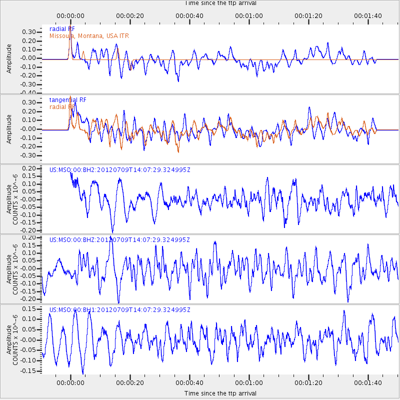
Signal To Noise
| Channel | StoN | STA | LTA |
| US:MSO:00:BHZ:20120709T14:07:29.324995Z | 0.7889804 | 5.871586E-8 | 7.441992E-8 |
| US:MSO:00:BH1:20120709T14:07:29.324995Z | 1.9998928 | 1.0360448E-7 | 5.1805014E-8 |
| US:MSO:00:BH2:20120709T14:07:29.324995Z | 0.599448 | 5.0104358E-8 | 8.358416E-8 |
| Arrivals |
| Ps | |
| PpPs | |
| PsPs/PpSs | |


