You are here: Home > Network List > IU - Global Seismograph Network (GSN - IRIS/USGS) Stations List
> Station RSSD Black Hills, South Dakota, USA > Earthquake Result Viewer
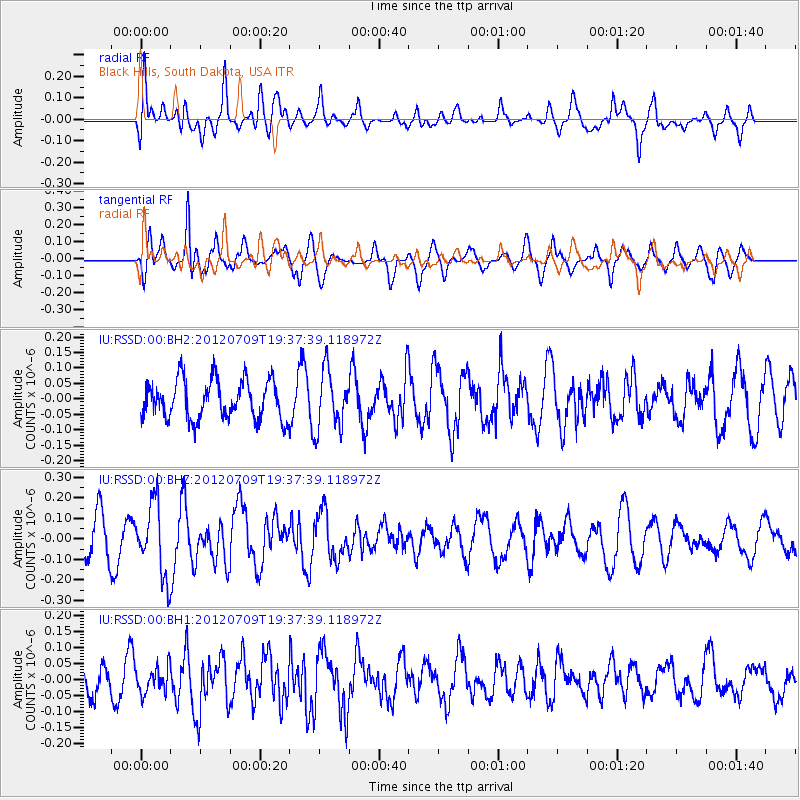
RSSD Black Hills, South Dakota, USA - Earthquake Result Viewer
*The percent match for this event was below the threshold and hence no stack was calculated.
| Earthquake location: |
Ryukyu Islands, Japan |
| Earthquake latitude/longitude: |
29.4/130.1 |
| Earthquake time(UTC): |
2012/07/09 (191) 19:25:07 GMT |
| Earthquake Depth: |
39 km |
| Earthquake Magnitude: |
5.6 MW, 5.1 MS, 5.1 MB, 5.5 MW |
| Earthquake Catalog/Contributor: |
WHDF/NEIC |
|
| Network: |
IU Global Seismograph Network (GSN - IRIS/USGS) |
| Station: |
RSSD Black Hills, South Dakota, USA |
| Lat/Lon: |
44.12 N/104.04 W |
| Elevation: |
2090 m |
|
| Distance: |
91.7 deg |
| Az: |
35.726 deg |
| Baz: |
314.959 deg |
| Ray Param: |
$rayparam |
*The percent match for this event was below the threshold and hence was not used in the summary stack. |
|
| Radial Match: |
60.884926 % |
| Radial Bump: |
400 |
| Transverse Match: |
65.54712 % |
| Transverse Bump: |
400 |
| SOD ConfigId: |
558545 |
| Insert Time: |
2013-09-19 21:57:32.719 +0000 |
| GWidth: |
2.5 |
| Max Bumps: |
400 |
| Tol: |
0.001 |
|
Signal To Noise
| Channel | StoN | STA | LTA |
| IU:RSSD:00:BHZ:20120709T19:37:39.118972Z | 2.0159974 | 1.7499696E-7 | 8.680416E-8 |
| IU:RSSD:00:BH1:20120709T19:37:39.118972Z | 0.5022378 | 3.962047E-8 | 7.888787E-8 |
| IU:RSSD:00:BH2:20120709T19:37:39.118972Z | 1.5257641 | 9.569077E-8 | 6.271662E-8 |
| Arrivals |
| Ps | |
| PpPs | |
| PsPs/PpSs | |


