You are here: Home > Network List > US - United States National Seismic Network Stations List
> Station BOZ Bozeman, Montana, USA > Earthquake Result Viewer
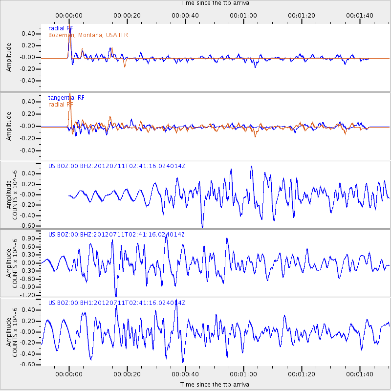
BOZ Bozeman, Montana, USA - Earthquake Result Viewer
*The percent match for this event was below the threshold and hence no stack was calculated.
| Earthquake location: |
Kuril Islands |
| Earthquake latitude/longitude: |
45.4/151.4 |
| Earthquake time(UTC): |
2012/07/11 (193) 02:31:16 GMT |
| Earthquake Depth: |
10 km |
| Earthquake Magnitude: |
5.6 MB, 5.5 MS, 5.7 MW, 5.7 MW |
| Earthquake Catalog/Contributor: |
WHDF/NEIC |
|
| Network: |
US United States National Seismic Network |
| Station: |
BOZ Bozeman, Montana, USA |
| Lat/Lon: |
45.65 N/111.63 W |
| Elevation: |
1589 m |
|
| Distance: |
63.5 deg |
| Az: |
51.077 deg |
| Baz: |
308.613 deg |
| Ray Param: |
$rayparam |
*The percent match for this event was below the threshold and hence was not used in the summary stack. |
|
| Radial Match: |
65.736336 % |
| Radial Bump: |
400 |
| Transverse Match: |
53.928005 % |
| Transverse Bump: |
400 |
| SOD ConfigId: |
558545 |
| Insert Time: |
2013-09-19 22:00:42.476 +0000 |
| GWidth: |
2.5 |
| Max Bumps: |
400 |
| Tol: |
0.001 |
|
Signal To Noise
| Channel | StoN | STA | LTA |
| US:BOZ:00:BHZ:20120711T02:41:16.024014Z | 2.2361376 | 2.636727E-7 | 1.1791434E-7 |
| US:BOZ:00:BH1:20120711T02:41:16.024014Z | 1.8392363 | 1.8856093E-7 | 1.0252132E-7 |
| US:BOZ:00:BH2:20120711T02:41:16.024014Z | 2.6187506 | 1.6698773E-7 | 6.376619E-8 |
| Arrivals |
| Ps | |
| PpPs | |
| PsPs/PpSs | |


