You are here: Home > Network List > US - United States National Seismic Network Stations List
> Station AMTX Amarillo, Texas, USA > Earthquake Result Viewer
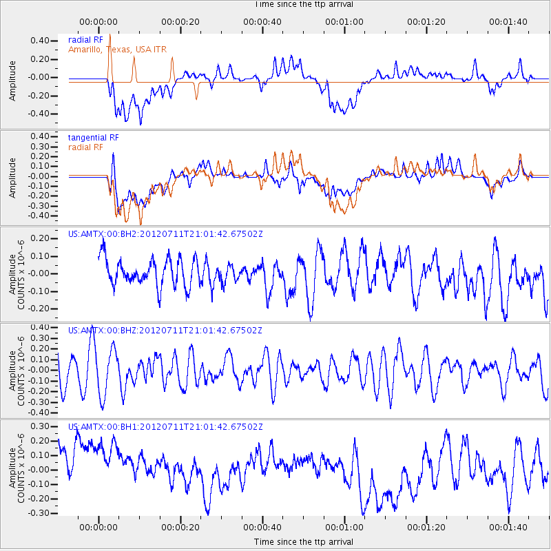
AMTX Amarillo, Texas, USA - Earthquake Result Viewer
*The percent match for this event was below the threshold and hence no stack was calculated.
| Earthquake location: |
Near Coast Of Peru |
| Earthquake latitude/longitude: |
-15.3/-75.3 |
| Earthquake time(UTC): |
2012/07/11 (193) 20:52:37 GMT |
| Earthquake Depth: |
14 km |
| Earthquake Magnitude: |
5.6 MW |
| Earthquake Catalog/Contributor: |
NEIC PDE/NEIC PDE-M |
|
| Network: |
US United States National Seismic Network |
| Station: |
AMTX Amarillo, Texas, USA |
| Lat/Lon: |
34.53 N/101.41 W |
| Elevation: |
1010 m |
|
| Distance: |
55.4 deg |
| Az: |
333.799 deg |
| Baz: |
148.927 deg |
| Ray Param: |
$rayparam |
*The percent match for this event was below the threshold and hence was not used in the summary stack. |
|
| Radial Match: |
27.463297 % |
| Radial Bump: |
400 |
| Transverse Match: |
45.772766 % |
| Transverse Bump: |
400 |
| SOD ConfigId: |
558545 |
| Insert Time: |
2013-09-19 22:05:42.544 +0000 |
| GWidth: |
2.5 |
| Max Bumps: |
400 |
| Tol: |
0.001 |
|
Signal To Noise
| Channel | StoN | STA | LTA |
| US:AMTX:00:BHZ:20120711T21:01:42.67502Z | 1.3731391 | 2.1772924E-7 | 1.5856313E-7 |
| US:AMTX:00:BH1:20120711T21:01:42.67502Z | 1.1544505 | 3.7152043E-7 | 3.218158E-7 |
| US:AMTX:00:BH2:20120711T21:01:42.67502Z | 0.8477786 | 6.426556E-8 | 7.580465E-8 |
| Arrivals |
| Ps | |
| PpPs | |
| PsPs/PpSs | |


