You are here: Home > Network List > US - United States National Seismic Network Stations List
> Station BLA Blacksburg, Virginia, USA > Earthquake Result Viewer
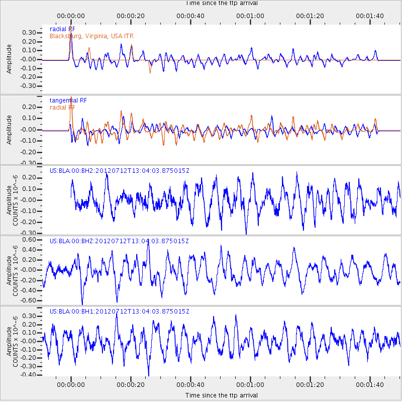
BLA Blacksburg, Virginia, USA - Earthquake Result Viewer
*The percent match for this event was below the threshold and hence no stack was calculated.
| Earthquake location: |
Kuril Islands |
| Earthquake latitude/longitude: |
45.5/151.7 |
| Earthquake time(UTC): |
2012/07/12 (194) 12:51:58 GMT |
| Earthquake Depth: |
12 km |
| Earthquake Magnitude: |
5.5 MB, 5.6 MS, 5.8 MW, 5.7 MW |
| Earthquake Catalog/Contributor: |
WHDF/NEIC |
|
| Network: |
US United States National Seismic Network |
| Station: |
BLA Blacksburg, Virginia, USA |
| Lat/Lon: |
37.21 N/80.42 W |
| Elevation: |
634 m |
|
| Distance: |
85.3 deg |
| Az: |
39.198 deg |
| Baz: |
326.136 deg |
| Ray Param: |
$rayparam |
*The percent match for this event was below the threshold and hence was not used in the summary stack. |
|
| Radial Match: |
56.037216 % |
| Radial Bump: |
400 |
| Transverse Match: |
59.2204 % |
| Transverse Bump: |
400 |
| SOD ConfigId: |
558545 |
| Insert Time: |
2013-09-19 22:10:17.056 +0000 |
| GWidth: |
2.5 |
| Max Bumps: |
400 |
| Tol: |
0.001 |
|
Signal To Noise
| Channel | StoN | STA | LTA |
| US:BLA:00:BHZ:20120712T13:04:03.875015Z | 1.9434849 | 2.5285965E-7 | 1.3010632E-7 |
| US:BLA:00:BH1:20120712T13:04:03.875015Z | 1.5918514 | 1.1772262E-7 | 7.3953274E-8 |
| US:BLA:00:BH2:20120712T13:04:03.875015Z | 0.5927579 | 4.8464766E-8 | 8.176149E-8 |
| Arrivals |
| Ps | |
| PpPs | |
| PsPs/PpSs | |


