You are here: Home > Network List > US - United States National Seismic Network Stations List
> Station MNTX Cornudas Mountains, Texas, USA > Earthquake Result Viewer
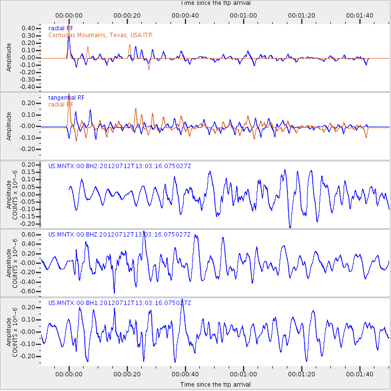
MNTX Cornudas Mountains, Texas, USA - Earthquake Result Viewer
*The percent match for this event was below the threshold and hence no stack was calculated.
| Earthquake location: |
Kuril Islands |
| Earthquake latitude/longitude: |
45.5/151.7 |
| Earthquake time(UTC): |
2012/07/12 (194) 12:51:58 GMT |
| Earthquake Depth: |
12 km |
| Earthquake Magnitude: |
5.5 MB, 5.6 MS, 5.8 MW, 5.7 MW |
| Earthquake Catalog/Contributor: |
WHDF/NEIC |
|
| Network: |
US United States National Seismic Network |
| Station: |
MNTX Cornudas Mountains, Texas, USA |
| Lat/Lon: |
31.70 N/105.38 W |
| Elevation: |
404 m |
|
| Distance: |
76.3 deg |
| Az: |
58.765 deg |
| Baz: |
315.082 deg |
| Ray Param: |
$rayparam |
*The percent match for this event was below the threshold and hence was not used in the summary stack. |
|
| Radial Match: |
57.29906 % |
| Radial Bump: |
361 |
| Transverse Match: |
66.90486 % |
| Transverse Bump: |
354 |
| SOD ConfigId: |
558545 |
| Insert Time: |
2013-09-19 22:11:58.763 +0000 |
| GWidth: |
2.5 |
| Max Bumps: |
400 |
| Tol: |
0.001 |
|
Signal To Noise
| Channel | StoN | STA | LTA |
| US:MNTX:00:BHZ:20120712T13:03:16.075027Z | 2.3002977 | 1.4725734E-7 | 6.4016646E-8 |
| US:MNTX:00:BH1:20120712T13:03:16.075027Z | 2.2915714 | 1.06761796E-7 | 4.65889E-8 |
| US:MNTX:00:BH2:20120712T13:03:16.075027Z | 1.0939618 | 4.3842533E-8 | 4.007684E-8 |
| Arrivals |
| Ps | |
| PpPs | |
| PsPs/PpSs | |


