You are here: Home > Network List > GS - US Geological Survey Networks Stations List
> Station DEC12 Decatur Surface Seismic Site, Decatur, IL, USA > Earthquake Result Viewer
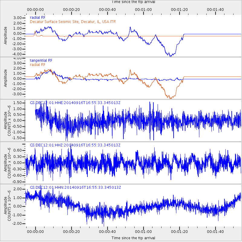
DEC12 Decatur Surface Seismic Site, Decatur, IL, USA - Earthquake Result Viewer
*The percent match for this event was below the threshold and hence no stack was calculated.
| Earthquake location: |
South Of Panama |
| Earthquake latitude/longitude: |
7.6/-82.4 |
| Earthquake time(UTC): |
2014/09/16 (259) 16:49:33 GMT |
| Earthquake Depth: |
25 km |
| Earthquake Magnitude: |
5.1 MW |
| Earthquake Catalog/Contributor: |
ISC/ISC |
|
| Network: |
GS US Geological Survey Networks |
| Station: |
DEC12 Decatur Surface Seismic Site, Decatur, IL, USA |
| Lat/Lon: |
39.91 N/88.91 W |
| Elevation: |
208 m |
|
| Distance: |
32.7 deg |
| Az: |
350.681 deg |
| Baz: |
167.954 deg |
| Ray Param: |
$rayparam |
*The percent match for this event was below the threshold and hence was not used in the summary stack. |
|
| Radial Match: |
27.67566 % |
| Radial Bump: |
400 |
| Transverse Match: |
51.387722 % |
| Transverse Bump: |
400 |
| SOD ConfigId: |
3390531 |
| Insert Time: |
2019-04-14 02:16:51.002 +0000 |
| GWidth: |
2.5 |
| Max Bumps: |
400 |
| Tol: |
0.001 |
|
Signal To Noise
| Channel | StoN | STA | LTA |
| GS:DEC12:01:HHZ:20140916T16:55:33.345013Z | 1.1353582 | 2.9602288E-7 | 2.6073084E-7 |
| GS:DEC12:01:HHN:20140916T16:55:33.345013Z | 1.708366 | 2.4202802E-6 | 1.4167223E-6 |
| GS:DEC12:01:HHE:20140916T16:55:33.345013Z | 0.82593656 | 5.337986E-7 | 6.4629495E-7 |
| Arrivals |
| Ps | |
| PpPs | |
| PsPs/PpSs | |


