You are here: Home > Network List > IU - Global Seismograph Network (GSN - IRIS/USGS) Stations List
> Station RSSD Black Hills, South Dakota, USA > Earthquake Result Viewer
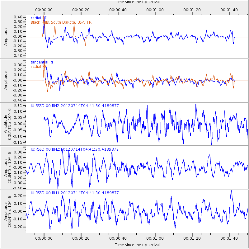
RSSD Black Hills, South Dakota, USA - Earthquake Result Viewer
*The percent match for this event was below the threshold and hence no stack was calculated.
| Earthquake location: |
Kuril Islands |
| Earthquake latitude/longitude: |
45.5/151.3 |
| Earthquake time(UTC): |
2012/07/14 (196) 04:30:58 GMT |
| Earthquake Depth: |
10 km |
| Earthquake Magnitude: |
5.5 MW |
| Earthquake Catalog/Contributor: |
NEIC PDE/NEIC PDE-M |
|
| Network: |
IU Global Seismograph Network (GSN - IRIS/USGS) |
| Station: |
RSSD Black Hills, South Dakota, USA |
| Lat/Lon: |
44.12 N/104.04 W |
| Elevation: |
2090 m |
|
| Distance: |
68.6 deg |
| Az: |
48.462 deg |
| Baz: |
313.051 deg |
| Ray Param: |
$rayparam |
*The percent match for this event was below the threshold and hence was not used in the summary stack. |
|
| Radial Match: |
68.0907 % |
| Radial Bump: |
400 |
| Transverse Match: |
55.123043 % |
| Transverse Bump: |
400 |
| SOD ConfigId: |
558545 |
| Insert Time: |
2013-09-19 22:20:41.254 +0000 |
| GWidth: |
2.5 |
| Max Bumps: |
400 |
| Tol: |
0.001 |
|
Signal To Noise
| Channel | StoN | STA | LTA |
| IU:RSSD:00:BHZ:20120714T04:41:30.418987Z | 2.5887303 | 1.6133883E-7 | 6.232354E-8 |
| IU:RSSD:00:BH1:20120714T04:41:30.418987Z | 1.5852906 | 1.0227164E-7 | 6.451287E-8 |
| IU:RSSD:00:BH2:20120714T04:41:30.418987Z | 1.3446616 | 6.367231E-8 | 4.735192E-8 |
| Arrivals |
| Ps | |
| PpPs | |
| PsPs/PpSs | |


