You are here: Home > Network List > IU - Global Seismograph Network (GSN - IRIS/USGS) Stations List
> Station PMG Port Moresby, New Guinea > Earthquake Result Viewer
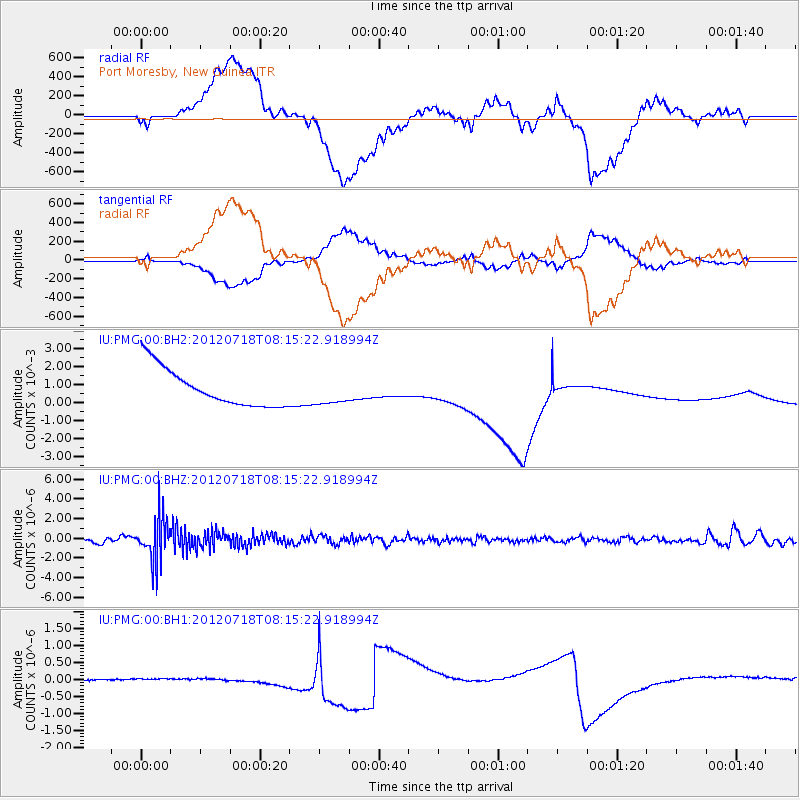
PMG Port Moresby, New Guinea - Earthquake Result Viewer
*The percent match for this event was below the threshold and hence no stack was calculated.
| Earthquake location: |
Fiji Islands Region |
| Earthquake latitude/longitude: |
-20.9/-178.5 |
| Earthquake time(UTC): |
2012/07/18 (200) 08:09:46 GMT |
| Earthquake Depth: |
537 km |
| Earthquake Magnitude: |
5.5 MB, 5.9 MW, 6.0 MW |
| Earthquake Catalog/Contributor: |
WHDF/NEIC |
|
| Network: |
IU Global Seismograph Network (GSN - IRIS/USGS) |
| Station: |
PMG Port Moresby, New Guinea |
| Lat/Lon: |
9.40 S/147.16 E |
| Elevation: |
90 m |
|
| Distance: |
35.0 deg |
| Az: |
283.81 deg |
| Baz: |
113.023 deg |
| Ray Param: |
$rayparam |
*The percent match for this event was below the threshold and hence was not used in the summary stack. |
|
| Radial Match: |
20.119993 % |
| Radial Bump: |
400 |
| Transverse Match: |
20.043886 % |
| Transverse Bump: |
400 |
| SOD ConfigId: |
558545 |
| Insert Time: |
2013-09-19 22:32:41.832 +0000 |
| GWidth: |
2.5 |
| Max Bumps: |
400 |
| Tol: |
0.001 |
|
Signal To Noise
| Channel | StoN | STA | LTA |
| IU:PMG:00:BHZ:20120718T08:15:22.918994Z | 7.892805 | 2.2421286E-6 | 2.8407248E-7 |
| IU:PMG:00:BH1:20120718T08:15:22.918994Z | 1.1785302 | 1.3784108E-7 | 1.16960166E-7 |
| IU:PMG:00:BH2:20120718T08:15:22.918994Z | 0.68865174 | 7.2426186E-4 | 0.00105171 |
| Arrivals |
| Ps | |
| PpPs | |
| PsPs/PpSs | |


