You are here: Home > Network List > US - United States National Seismic Network Stations List
> Station ERPA Erie, Pennsylvania, USA > Earthquake Result Viewer
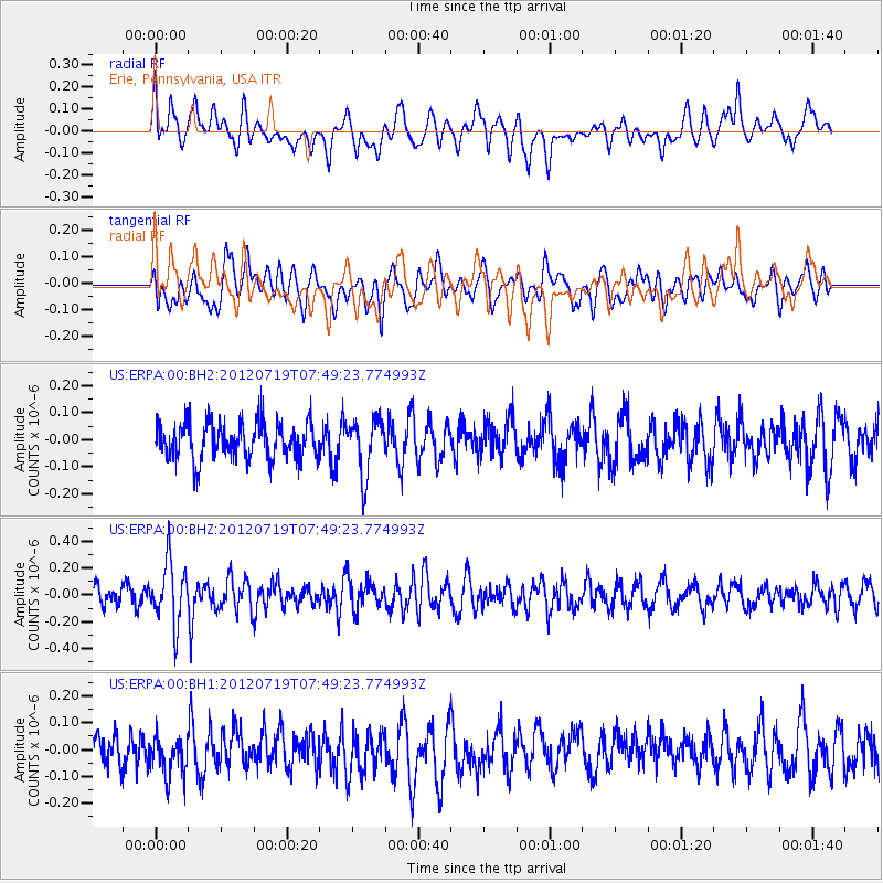
ERPA Erie, Pennsylvania, USA - Earthquake Result Viewer
*The percent match for this event was below the threshold and hence no stack was calculated.
| Earthquake location: |
Afghanistan-Tajikistan Bord Reg. |
| Earthquake latitude/longitude: |
37.2/71.4 |
| Earthquake time(UTC): |
2012/07/19 (201) 07:36:35 GMT |
| Earthquake Depth: |
98 km |
| Earthquake Magnitude: |
5.5 MB, 5.6 MW, 5.6 MW |
| Earthquake Catalog/Contributor: |
WHDF/NEIC |
|
| Network: |
US United States National Seismic Network |
| Station: |
ERPA Erie, Pennsylvania, USA |
| Lat/Lon: |
42.12 N/79.99 W |
| Elevation: |
306 m |
|
| Distance: |
96.8 deg |
| Az: |
338.956 deg |
| Baz: |
22.652 deg |
| Ray Param: |
$rayparam |
*The percent match for this event was below the threshold and hence was not used in the summary stack. |
|
| Radial Match: |
55.408104 % |
| Radial Bump: |
400 |
| Transverse Match: |
51.391186 % |
| Transverse Bump: |
400 |
| SOD ConfigId: |
558545 |
| Insert Time: |
2013-09-19 22:35:42.740 +0000 |
| GWidth: |
2.5 |
| Max Bumps: |
400 |
| Tol: |
0.001 |
|
Signal To Noise
| Channel | StoN | STA | LTA |
| US:ERPA:00:BHZ:20120719T07:49:23.774993Z | 3.112498 | 2.282205E-7 | 7.33239E-8 |
| US:ERPA:00:BH1:20120719T07:49:23.774993Z | 0.78173536 | 7.349869E-8 | 9.401991E-8 |
| US:ERPA:00:BH2:20120719T07:49:23.774993Z | 1.5303633 | 1.0245474E-7 | 6.694798E-8 |
| Arrivals |
| Ps | |
| PpPs | |
| PsPs/PpSs | |


