You are here: Home > Network List > US - United States National Seismic Network Stations List
> Station HAWA Hanford, Washington, USA > Earthquake Result Viewer
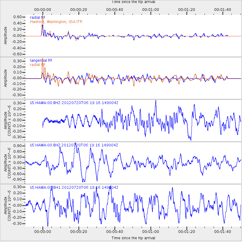
HAWA Hanford, Washington, USA - Earthquake Result Viewer
*The percent match for this event was below the threshold and hence no stack was calculated.
| Earthquake location: |
Kuril Islands |
| Earthquake latitude/longitude: |
49.4/155.9 |
| Earthquake time(UTC): |
2012/07/20 (202) 06:10:25 GMT |
| Earthquake Depth: |
19 km |
| Earthquake Magnitude: |
5.7 MB, 5.7 MS, 6.0 MW, 6.1 MW |
| Earthquake Catalog/Contributor: |
WHDF/NEIC |
|
| Network: |
US United States National Seismic Network |
| Station: |
HAWA Hanford, Washington, USA |
| Lat/Lon: |
46.39 N/119.53 W |
| Elevation: |
364 m |
|
| Distance: |
53.9 deg |
| Az: |
58.528 deg |
| Baz: |
306.399 deg |
| Ray Param: |
$rayparam |
*The percent match for this event was below the threshold and hence was not used in the summary stack. |
|
| Radial Match: |
74.590126 % |
| Radial Bump: |
400 |
| Transverse Match: |
77.72959 % |
| Transverse Bump: |
400 |
| SOD ConfigId: |
558545 |
| Insert Time: |
2013-09-19 22:39:11.266 +0000 |
| GWidth: |
2.5 |
| Max Bumps: |
400 |
| Tol: |
0.001 |
|
Signal To Noise
| Channel | StoN | STA | LTA |
| US:HAWA:00:BHZ:20120720T06:19:16.149004Z | 3.3184772 | 2.6616664E-7 | 8.020746E-8 |
| US:HAWA:00:BH1:20120720T06:19:16.149004Z | 2.1995819 | 1.4185072E-7 | 6.448986E-8 |
| US:HAWA:00:BH2:20120720T06:19:16.149004Z | 1.2447324 | 6.873162E-8 | 5.5217992E-8 |
| Arrivals |
| Ps | |
| PpPs | |
| PsPs/PpSs | |


