You are here: Home > Network List > US - United States National Seismic Network Stations List
> Station LONY Lake Ozonia, New York, USA > Earthquake Result Viewer
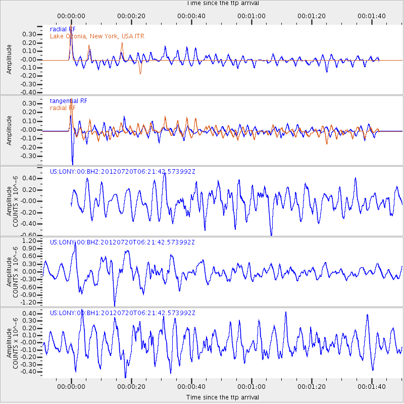
LONY Lake Ozonia, New York, USA - Earthquake Result Viewer
*The percent match for this event was below the threshold and hence no stack was calculated.
| Earthquake location: |
Kuril Islands |
| Earthquake latitude/longitude: |
49.4/155.9 |
| Earthquake time(UTC): |
2012/07/20 (202) 06:10:25 GMT |
| Earthquake Depth: |
19 km |
| Earthquake Magnitude: |
5.7 MB, 5.7 MS, 6.0 MW, 6.1 MW |
| Earthquake Catalog/Contributor: |
WHDF/NEIC |
|
| Network: |
US United States National Seismic Network |
| Station: |
LONY Lake Ozonia, New York, USA |
| Lat/Lon: |
44.62 N/74.58 W |
| Elevation: |
440 m |
|
| Distance: |
76.5 deg |
| Az: |
34.513 deg |
| Baz: |
328.785 deg |
| Ray Param: |
$rayparam |
*The percent match for this event was below the threshold and hence was not used in the summary stack. |
|
| Radial Match: |
66.86014 % |
| Radial Bump: |
367 |
| Transverse Match: |
63.73801 % |
| Transverse Bump: |
400 |
| SOD ConfigId: |
558545 |
| Insert Time: |
2013-09-19 22:39:36.587 +0000 |
| GWidth: |
2.5 |
| Max Bumps: |
400 |
| Tol: |
0.001 |
|
Signal To Noise
| Channel | StoN | STA | LTA |
| US:LONY:00:BHZ:20120720T06:21:42.573992Z | 2.7718568 | 5.9701534E-7 | 2.1538462E-7 |
| US:LONY:00:BH1:20120720T06:21:42.573992Z | 1.8875884 | 2.1980507E-7 | 1.16447566E-7 |
| US:LONY:00:BH2:20120720T06:21:42.573992Z | 1.6372515 | 2.7487363E-7 | 1.6788724E-7 |
| Arrivals |
| Ps | |
| PpPs | |
| PsPs/PpSs | |


