You are here: Home > Network List > US - United States National Seismic Network Stations List
> Station BLA Blacksburg, Virginia, USA > Earthquake Result Viewer
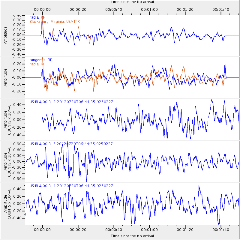
BLA Blacksburg, Virginia, USA - Earthquake Result Viewer
*The percent match for this event was below the threshold and hence no stack was calculated.
| Earthquake location: |
Kuril Islands |
| Earthquake latitude/longitude: |
49.4/156.1 |
| Earthquake time(UTC): |
2012/07/20 (202) 06:32:56 GMT |
| Earthquake Depth: |
10 km |
| Earthquake Magnitude: |
5.8 MB, 5.5 MS, 5.8 MW, 5.9 MW |
| Earthquake Catalog/Contributor: |
WHDF/NEIC |
|
| Network: |
US United States National Seismic Network |
| Station: |
BLA Blacksburg, Virginia, USA |
| Lat/Lon: |
37.21 N/80.42 W |
| Elevation: |
634 m |
|
| Distance: |
80.3 deg |
| Az: |
42.511 deg |
| Baz: |
326.395 deg |
| Ray Param: |
$rayparam |
*The percent match for this event was below the threshold and hence was not used in the summary stack. |
|
| Radial Match: |
59.31078 % |
| Radial Bump: |
400 |
| Transverse Match: |
59.124115 % |
| Transverse Bump: |
400 |
| SOD ConfigId: |
558545 |
| Insert Time: |
2013-09-19 22:42:21.606 +0000 |
| GWidth: |
2.5 |
| Max Bumps: |
400 |
| Tol: |
0.001 |
|
Signal To Noise
| Channel | StoN | STA | LTA |
| US:BLA:00:BHZ:20120720T06:44:35.925022Z | 2.6070993 | 3.4044024E-7 | 1.30582E-7 |
| US:BLA:00:BH1:20120720T06:44:35.925022Z | 1.1347548 | 1.3937927E-7 | 1.2282766E-7 |
| US:BLA:00:BH2:20120720T06:44:35.925022Z | 0.7436406 | 1.1320324E-7 | 1.5222844E-7 |
| Arrivals |
| Ps | |
| PpPs | |
| PsPs/PpSs | |


